Galleria foto
- Lenght
- 13.10 km
- Tempo
- 4 hours
- Tappa
Elenco risultati
- Ascent elevation gain
- 190 m
- Descent elevation loss
- 1720 m
- Difficulty
- Hiking
- Itinerary index
- No
Informazioni
Punto di partenza
Alpe La Colma
28803 Premosello Chiovenda VB
Italy
Punto di arrivo
Vogogna
28805 Vogogna VB
Italy
Come arrivare
Vogogna can be reached by car, train and bus
Descrizione
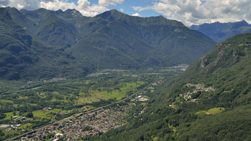
From the bivouac of Alpe La Colma, descend to Premosello along trail VBAA40, on a visible track, first through mountain pastures, then into a broadleaf forest, reaching the alpine pastures of La Motta (1139 m) and La Piana (999 m). Just beyond the centre of Alpe La Piana, you reach the starting point of the Colloro-Bacino-Alpe Lut-La Piana municipal road at an altitude of 960 m. Take it and then go downhill up to the junction for Alpe Lut, at an altitude of 800 m. At the junction, take the mule track that climbs to the right, reach Alpe Lut and, along trail VBAA38A, return to the municipal road and follow it to Colloro (500 m). In Colloro, continue along via Fontana del Bosco, to the far western side of the village. From here, along trail VBAA36, go down to Premosello and take trail VBAA00 that runs along via Cuzzi. Leaving Premosello along via Cuzzi, the route reaches the geological observation point dedicated to peridotites, which belongs to the geological trail of Vogogna-Premosello. After a short segment on SP 166 of Ossola Valley, the itinerary runs along the above-mentioned thematic route towards Vogogna (trail VBAA00D), climbing the rocky crags facing the valley floor of the river Toce, up to the ancient fortress of Rocca di Vogogna. The route goes further, along trail VBAA34A, to the hamlet of Genestredo (340 m) and from there, on a steep mule track, it reaches the Castle and the historic centre of Vogogna, where the leg ends.
Recommended period
Accessible to people with disabilities
Support points
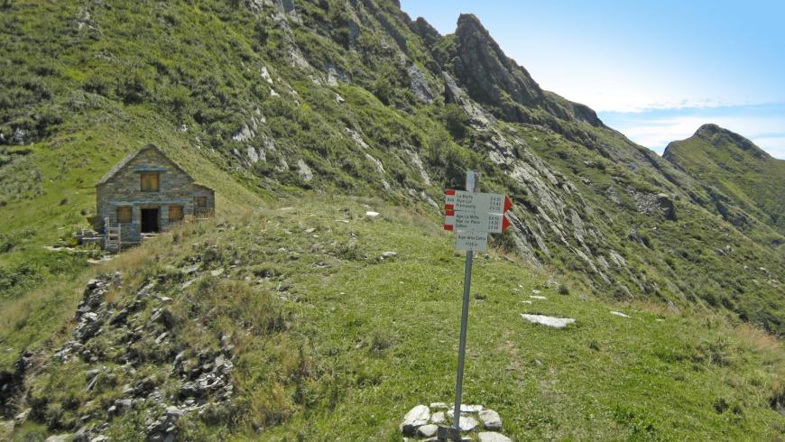
Bivouac of La Colma
Interest points
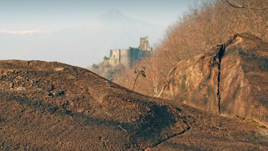
Between Vogogna and Premosello you can follow a geological itinerary equipped with didactic panels. The trail offers the exceptional opportunity to "cross" the continental crust, observing rocks that formed at different depths and in different periods. Along the equipped itinerary you pass from the European paleocontinent, involved in the genesis of the Alps (50 - 30 million years ago), to the African paleocontinent that preserves rocks and structures formed about 300 million years ago; at the same time you "descend" to the contact between the crust and the mantle, generally located at a depth of 30-35 km, here exhumed by tectonic processes. The route, equipped with explanatory didactic panels, climbs from the castle of Vogogna up to the Fortress and then it continues along the rocky crags overlooking the Toce plain up to Premosello. In the westernmost part, the route crosses the phyllite rocks deformed by friction along the Canavese Line, a strip along which the alpine construction overlapped the most ancient southern area of the Alps. A little further on, you can observe the direct contact between the rocks of these two areas (Schists of Fobello and Rimella and granulites of the deep crust of the Ivrea Verbano area). From a panoramic viewpoint, located on "sheepback" rocks, you can observe the pre- and post-glacial morphology of Toce Valley. After coming across the pseudotachylites, testimonies to ancient earthquakes, at the eastern end you can reach the contact between granulites and peridotites, which represents the discontinuity of Mohorovicic (or "Moho"), that is, the crust-mantle contact.
Dettagli
Profilo altimetrico
Dati tecnici
- Code
- VGP
- Classification
- Provincial - Mid and Low Altitude
- Cell phone coverage
Partial
- Country
- Italy
- Region
- Piemonte
- Province
- Verbania
- Devotional relevance
- No
- Historical relevance
- No
- Ultima data di aggiornamento
- 15/12/2023
Altre info
Accommodation facilities

Structure qualification
Del vecchio borgo
Località
VOGOGNA (VB)
Structure qualification
Valgrande hotel
Località
VOGOGNA (VB)
Structure qualification
Ca' dal preu
Località
PREMOSELLO-CHIOVENDA (VB)
Structure qualification
Monterosa
Località
VOGOGNA (VB)
Tappe
Tappe attività
-
-
1Via geoalpina: leg 1 cursolo ? refuge of pian vadàLunghezza19.40 kmTempo7 hoursDifficoltàHiking
-
1AVia geoalpina: leg 1a piancavallo - pian vadàLunghezza13.90 kmTempo4 hours 10 minutesDifficoltàHiking
-
2Via geoalpina: leg 2 refuge of pian vadà - alpe curgeiLunghezza8.50 kmTempo3 hoursDifficoltàDifficult Hiking
-
3Via geoalpina: leg 3 alpe curgei - alpe pian di boitLunghezza10.70 kmTempo4 hours 15 minutesDifficoltàHiking
-
4Via geoalpina: leg 4 alpe pian di boit - alpe scarediLunghezza9.50 kmTempo6 hours 45 minutesDifficoltàHiking
-
5Via geoalpina: leg 5 alpe scaredi - alpe la colmaLunghezza12.10 kmTempo7 hours 45 minutesDifficoltàHiking
-
6Via geoalpina: leg 6 alpe la colma ? vogognaLunghezza13.10 kmTempo4 hoursDifficoltàHiking
-
7Via geoalpina: leg 7 vogogna - campello montiLunghezza19.60 kmTempo7 hours 30 minutesDifficoltàHiking