- Lenght
- 8.10 km
- Tempo
- 4 hours
- Tappa
- Max altitude
- 2475 m
- Ascent elevation gain
- 450 m
- Descent elevation loss
- 700 m
- Difficulty
- Hiking
- Itinerary index
- No
Informazioni
Punto di partenza
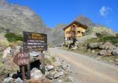
Rifugio Ellena-Soria
Pian del Praiet
12010 Entracque CN
Italy
Punto di arrivo
Rifugio Genova-Figari
Strada Comunale Rovine
12010 Entracque CN
Italy
Come arrivare
Descrizione
From the Ellena-Soria refuge, take the M10 mule track to the right, which climbs towards the NW, passes the Gias Alvé (1840 m) and climbs with numerous hairpin bends to the orographic left of the Vallone di Fenestrelle. The mule track reaches the ruins of Gias Balmetta (2157 m), then leaves the track to the right for Gias Confurci (2281 m). From here it crosses the top of the valley, passes a small lake (c. 2410 m), a ruined ex-military shelter and reaches the Gesso della Barra-Rovina watershed where the Colle di Fenestrelle (2463 m) opens out. From the pass, the M10 path, past a few puddles of water, descends towards the N on the Rovina slope (Chiotàs Basin) with a winding route, then, after a short ascent, leads to the western slopes of Punta Ciamberline; from here it continues with a semicircular route, the descent until it connects, at an altitude of c. 2000 m, to the cart-track (M8) which, beyond the Chiotàs basin soon reaches the Genova-Figari Refuge (2010 m) on the shore of Lake Bròcan.
Recommended period
Accessible to people with disabilities
Dettagli
Profilo altimetrico
Dati tecnici
- Code
- AVU
- Classification
- Provincial - Mid and Low Altitude
- Country
- Italy
- Region
- Piemonte
- Province
- Cuneo
- Devotional relevance
- No
- Historical relevance
- No
- Ultima data di aggiornamento
- 15/12/2023
Altre info
Tappe
Tappe attività
-
0AVU - Alta Via dei LupiLunghezza206.00 kmTempo2 days 8 hours 30 minutesDifficoltàDifficult Hiking
-
1AVU Stage 1: Pian delle Gorre - Rifugio MondovìLunghezza12.00 kmTempo6 hoursDifficoltàHiking
-
1AAVU Stage 1A: Pian delle Gorre - Gias Soprano SestreraLunghezza3.50 kmTempo2 hours 30 minutesDifficoltàHiking
-
2AVU Stage 2: Rifugio Mondovì - Rifugio Don BarberaLunghezza14.50 kmTempo5 hoursDifficoltàHiking
-
2AAVU Stage 2A: Tetti delle Donzelle - Rifugio Havis De Giorgio - MondovìLunghezza4.00 kmTempo2 hoursDifficoltàHiking
-
3AVU Stage 3: Rifugio Don Barbera - LimonettoLunghezza20.50 kmTempo7 hoursDifficoltàHiking
-
3AAVU Stage 3A: crossroad stage 03 - Vallone del SaltoLunghezza13.60 kmTempo5 hoursDifficoltàHiking
-
4AVU Tappa 4: Limonetto - PalanfrèLunghezza11.00 kmTempo4 hoursDifficoltàHiking
-
4AAVU Stage 4A: Limone Piemonte - LimonettoLunghezza4.40 kmTempo1 hour 15 minutesDifficoltàTouristic
-
5AVU Stage 5: Palanfrè - TrinitàLunghezza11.40 kmTempo5 hoursDifficoltàHiking
-
5AAVU Stage 5A: Palanfrè - VernanteLunghezza11.90 kmTempo3 hoursDifficoltàHiking
-
5BAVU Stage 5B: Trinità - Colle Ovest del SabbioneLunghezza13.20 kmTempo6 hoursDifficoltàDifficult Hiking
-
5CAVU Stage 5C: Gias Valera Sottano - Lago degli AlberghiLunghezza4.60 kmTempo3 hoursDifficoltàDifficult Hiking
-
6AVU Stage 6: Trinità - San Giacomo di EntracqueLunghezza13.50 kmTempo4 hoursDifficoltàHiking
-
7AVU Stage 7: San Giacomo di Entracque - Rifugio Ellena-SoriaLunghezza6.10 kmTempo2 hours 30 minutesDifficoltàHiking
-
7AAVU Stage 7A: San Giacomo di Entracque - Rifugio Ellena-SoriaLunghezza21.20 kmTempo7 hoursDifficoltàHiking
-
8AVU Stage 8: Rifugio Ellena-Soria - Rifugio Genova-FigariLunghezza8.10 kmTempo4 hoursDifficoltàHiking
-
8AAVU Stage 8A: Lago Brocan - Terme di ValdieriLunghezza14.30 kmTempo6 hours 30 minutesDifficoltàHiking
-
9AVU Stage 9: Rifugio Genova-Figari - Rifugio Franco RemondinoLunghezza5.10 kmTempo4 hoursDifficoltàDifficult Hiking
-
9AAVU Stage 9A: crossroad near Colle Brocan - Colle Est del MercantourLunghezza1.60 kmTempo30 minutesDifficoltàDifficult Hiking
-
10AVU Stage 10: Rifugio Franco Remondino - Terme di ValdieriLunghezza9.58 kmTempo2 hours 31 minutesDifficoltàHiking

