- Lenght
- 7.87 km
- Tempo
- 1 hour 40 minutes
- Tappa
- Max altitude
- 694 m
- Ascent elevation gain
- 90 m
- Descent elevation loss
- 160 m
- Difficulty
- Hiking
- Itinerary index
- No
Informazioni
Punto di partenza
Cartignano
12020 Cartignano CN
Italy
Punto di arrivo
Dronero
12025 Dronero CN
Italy
Come arrivare
Descrizione
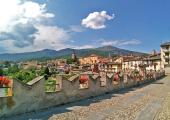
The last stage involves a path with no difference in height. From Cartignano we take the path downhill along cultivated fields and agricultural properties. In short, you reach Ponte Bedale (Bridge) and you take the agricultural path on the left, Tetti hamlet (Dronero). Once you have passed the village, the signs allow you to continue on the right, on asphalt, in the direction of the cycle-pedestrian track that you take nearby Ponte Olivengo (Bridge). Along the Maira stream and in the shade of towering chestnut trees you can reach the wide fields of the Archero region, close to the town of Dronero. A couple of kilometers still allow you to reach the charming Piazzetta Cariolo (Square), the heart of the medieval town of Dronero. You can not miss a photo shoot on the crenellated bridge, known as "Ponte del Diavolo" (Devil’s Bridge) (1428 AD), with its unequaled arches and framed by the peaks of the upper Maira valley.
Recommended period
Accessible to people with disabilities
Interest points
Ponte Vecchio, detto Del Diavolo. Ponte merlato caratteristico con le sue grandi arcate diseguali. Fu costruito nel 1428 sul torrente Maira per favorire l'accesso a Dronero e alla valle per chi veniva dalla piana di Cuneo.
Dettagli
Profilo altimetrico
Dati tecnici
- Code
- POC
- Classification
- Provincial - Mid and Low Altitude
- Local Tourist Agency (LTA) reference
- ATL del Cuneese - valli alpine e città d'arte
- Country
- Italy
- Region
- Piemonte
- Province
- Cuneo
- Devotional relevance
- No
- Historical relevance
- Yes
- Ultima data di aggiornamento
- 15/12/2023
Altre info
Tappe
Tappe attività
-
0POC - Percorsi occitaniLunghezza175.50 kmTempo2 days 10 hours 30 minutesDifficoltàHiking
-
1POC Tappa 1: Ciciu di Villar - Frazione Sant'Anna di RoccabrunaLunghezza16.05 kmTempo5 hoursDifficoltàHiking
-
2Percorsi Occitani: Tappa 2 Frazione Sant'Anna di Roccabruna - Frazione Pagliero di San Damiano MacraLunghezza8.54 kmTempo2 hours 45 minutesDifficoltàHiking
-
3Percorsi Occitani: Tappa 3 Frazione Pagliero di San Damiano Macra - Frazione CamoglieresLunghezza10.78 kmTempo3 hoursDifficoltàHiking
-
4Percorsi Occitani: Tappa 4 Frazione Camoglieres - San Martino InferioreLunghezza16.93 kmTempo5 hours 30 minutesDifficoltàHiking
-
5Percorsi Occitan: Tappa 5 San Martino Inferiore - ElvaLunghezza6.91 kmTempo2 hours 30 minutesDifficoltàHiking
-
6Percorsi Occitani: Tappa 6 Elva - San Michele di PrazzoLunghezza9.74 kmTempo3 hours 40 minutesDifficoltàHiking
-
7Percorsi Occitani: Tappa 7 San Michele di Prazzo - Borgata UssoloLunghezza5.94 kmTempo4 hoursDifficoltàHiking
-
8Percorsi Occitani: Tappa 8 Borgata Ussolo - Borgata ChiapperaLunghezza14.66 kmTempo4 hours 30 minutesDifficoltàHiking
-
9Percorsi Occitani: Tappa 9 Borgata Chiappera - Borgata ChialvettaLunghezza14.87 kmTempo4 hours 40 minutesDifficoltàHiking
-
10Percorsi Occitani: Tappa 10 Borgata Chialvetta - Rifugio della GardettaLunghezza7.55 kmTempo4 hours 15 minutesDifficoltàHiking
-
11Percorsi Occitani: Tappa 11 Rifugio della Gardetta - Borgata ArataLunghezza20.16 kmTempo6 hours 30 minutesDifficoltàHiking
-
12Percorsi Occitani: Tappa 12 Borgata Arata - Borgata PalentLunghezza9.12 kmTempo4 hours 10 minutesDifficoltàHiking
-
13Percorsi Occitani: Tappa 13 Borgata Palent - Borgata ChiesaLunghezza9.27 kmTempo2 hours 40 minutesDifficoltàHiking
-
14Percorsi Occitani: Tappa 14 Borgata Chiesa - CartignanoLunghezza19.60 kmTempo6 hours 10 minutesDifficoltàHiking
-
15Percorsi Occitani: Tappa 15 Cartignano - DroneroLunghezza7.87 kmTempo1 hour 40 minutesDifficoltàHiking


