- Lenght
- 7.50 km
- Tempo
- 4 hours
- Tappa
- Ascent elevation gain
- 550 m
- Descent elevation loss
- 600 m
- Difficulty
- Difficult Hiking
- Itinerary index
- No
Informazioni
Punto di partenza
Rifugio Gastaldi
10070 Balme TO
Italy
Punto di arrivo
Rifugio Cibrario
10070 Usseglio TO
Italy
Come arrivare
Descrizione
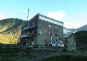
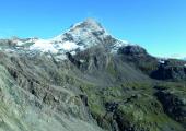
You follow the path that from the Gastaldi Refuge descends towards the exit of the Crot del Ciaussine basin, in the direction of a waterfall. This is formed by the river that flows from the basin below the Cresta del Fort. Once crossed the stream, the path climbs along the grassy and detrital slope between the waterfall and the walls of mount Rocca Affinau. After a short ascent, you will reach the crossroad to Colle d’Arnas. The itinerary suggests ignoring this indication, and following instead the traces on the left that go around Rocca Affinau, keeping in the valley on the left. With some steep turns, the path arrives to a valley where you will find some fusion lakes. Once reached the steep debris slopes that close the basin, a short and well-indicated track goes up in diagonal towards the left. This leads directly to Collarin Arnas (2850 m). The trail descends on steep rocks to Lake Rossa and its dam. Just before the dam, on the left, you will follow the path to the Bivouac San Camillo. After having crossed the dam, you follow the dirt road that surrounds the lake, and then turn left. You pass through the stream and resume the path on the hydrographic left as you proceed towards the bottom of the basin. You climb a ramp that starts at the height of a waterfall. With an easy route, you reach Colle Altare (2962 m). From the pass, you follow the trail that leads to a wide channel, in which, always remaining on the right side, and alternating ups and downs with steep slopes, you descend to a plateau dotted with pools of water and bounded by Lake Peraciaval. A well-marked path crosses the plain and leads you over the cliff that dominates the Piano del Sabiunin. From here, by means of few steep hairpin bends, you reach Rifuge Cibrario.
Recommended period
Accessible to people with disabilities
Itinerary suitable for disabled people.
Support points
Rifugio Gastaldi (2659 m) Località Ciausinet, 10070 Balme +39 0123 565008 - +39 348 3691127 info@rifugiogastaldi.com www.rifugiogastaldi.com. Apertura: da Aprile a Settembre. Posti letto: 99.
Bivacco San Camillo (2735 m) Località Lago della Rossa, 10070 Usseglio Apertura: sempre aperto. Posti letto: 20.
Rifugio Cibrario (2616 m) 10070 Usseglio +39 011 9988830 rifugiocibrario@caileini.it www.caileini.it/rifugiocibrario/. Apertura: da Giugno a Settembre. Posti letto: 42.
Dettagli
Profilo altimetrico
Dati tecnici
- Code
- TDB
- Classification
- Provincial - High altitude
- Country
- Italy
- Region
- Piemonte
- Province
- Torino
- Devotional relevance
- No
- Historical relevance
- Yes
- Ultima data di aggiornamento
- 15/12/2023
Altre info
Tappe
Tappe attività
-
0Tour della Bessanese (TB)Lunghezza32.00 kmTempo17 hoursDifficoltàDifficult Hiking
-
1Tour della Bessanese: Stage 1 Refuge Gastaldi - Refuge CibarioLunghezza7.50 kmTempo4 hoursDifficoltàDifficult Hiking
-
2Tour della Bessanese: Stage 2 Refuge Cibario - Refuge d’AveroleLunghezza15.20 kmTempo7 hoursDifficoltàDifficult Hiking
-
3Tour della Bessanese: Stage 3 Refuge d’Averole - Refuge GastaldiLunghezza9.30 kmTempo6 hoursDifficoltàEquipped Difficult Hiking


