- Lenght
- 2.52 km
- Tempo
- 1 hour
- Tappa
- Max altitude
- 1515 m
- Ascent elevation gain
- 200 m
- Descent elevation loss
- 50 m
- Difficulty
- Hiking
- Itinerary index
- No
Informazioni
Punto di partenza
Bivio tappa 4
12030 Crissolo CN
Italy
Punto di arrivo
Frazione Borgo
12030 Crissolo CN
Italy
Come arrivare
Highway A6 TORINO - SAVONA, exit: Marene; turn left for S.S. 662 towards Savigliano, continue until Saluzzo, then follow signs for Valle Po along S.P. 26 or S. P. 260;
Highway A21 TORINO – ALESSANDRIA – PIACENZA, exit Asti est – keep on for Alba- Bra- exit Marene- Savigliano- Saluzzo- Valle Po (S.S. 662);
From TORINO, Tangenziale, exit Pinerolo, keep on S.P. 161 then S.P .27 for Barge, Paesana.
There's no public transport line from Paesana to Pian Muné. Click here for taxi services: http://Www.vallidelmonviso.it/Come-raggiungerci-2/From Torino and Cuneo: Atibus, timetables on www.buscompany.it/Ati, lines Torino-Saluzzo, Cuneo-Saluzzo, Saluzzo-Paesana.
From Torino and Pinerolo: Autolinee Cavourese, timetables on www.cavourese.it, lines Torino – Pinerolo e Pinerolo - Barge.
From Barge and Paesana: timetables on www.unionemonviso.it, Unione Informa, line Barge - Paesana - Crissolo.
Descrizione
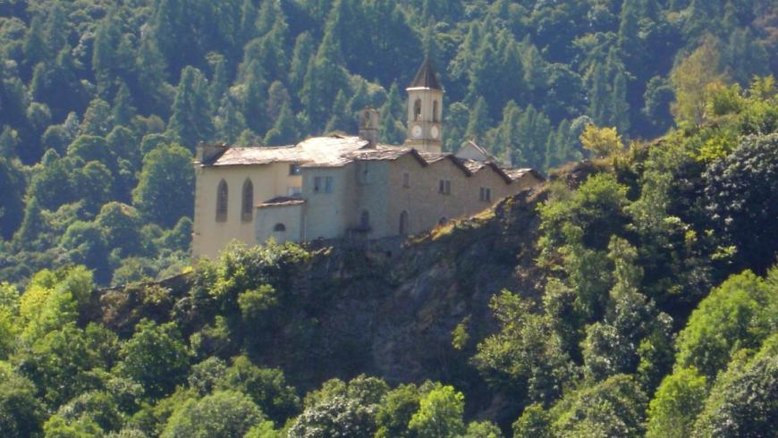
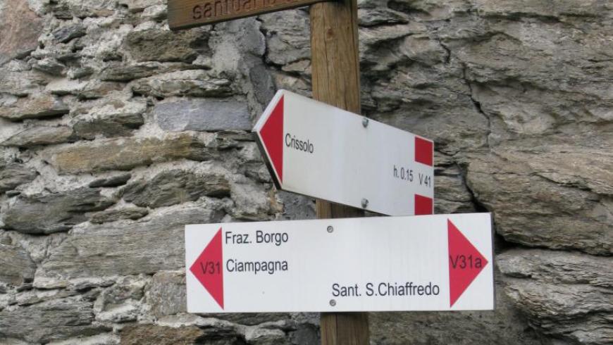
Interesting digression to the loop hike that allows you to visit the suggestive Sanctuary of San Chiaffredo, destination of thousands of devotees. From the center of Crissolo, follow the provincial road of Pian del Re (King's plain) to the fork at the hairpin bend, then turn right at the Sanctuary. Behind it, the mule track crosses the hillside on a steady gradient among wooded areas and open slopes reaching the Borgo hamlet, where it comes out onto the main Orizzonte Monviso track.
Recommended period
Accessible to people with disabilities
Support points
Crissolo toruristic facilities (http://www.vallidelmonviso.it/com_valle/crissolo-2/?valle=valle-po )
Interest points
San Chiaffredo's Sanctuary in Crissolo
Dettagli
Profilo altimetrico
Dati tecnici
- Code
- OMV
- Classification
- Provincial - Mid and Low Altitude
- Cell phone coverage
Good cell phone coverage in the city centres; less good in some itinerary's stretches.
- Country
- Italy
- Region
- Piemonte
- Province
- Cuneo
- Devotional relevance
- Sì
- Historical relevance
- Yes
- Ultima data di aggiornamento
- 15/12/2023
Altre info
Accommodation facilities

Club alpino
- Località
CRISSOLO (CN)
Il bucaneve
- Località
CRISSOLO (CN)
La tana del ghiro
- Località
CRISSOLO (CN)
Monviso
- Località
CRISSOLO (CN)
Visolotto
- Località
CRISSOLO (CN)
Tappe
Tappe attività
-
0Orizzonte MonvisoLunghezza74.89 kmTempo1 day 2 hours 35 minutesDifficoltàHiking
-
1Stage 1: rif. esc. la via del sale - rif. esc. pian munèLunghezza15.88 kmTempo5 hours 45 minutesDifficoltàHiking
-
2Orizzonte Monviso - Tappa 2: Rif. esc. Pian Muné - Rif. esc. LossaLunghezza13.08 kmTempo3 hours 45 minutesDifficoltàHiking
-
2AStage 1a: paesana - bivio quota 1435Lunghezza8.84 kmTempo4 hours 10 minutesDifficoltàHiking
-
2BOrizzonte Monviso - Tappa 2A: Rif. Esc. Pian Muné - bivio Croce Tournour (Paesana)Lunghezza8.34 kmTempo3 hoursDifficoltàHiking
-
3Stage 3: rif. esc. lossa - crissoloLunghezza9.86 kmTempo3 hours 50 minutesDifficoltàHiking
-
4Stage 4: crissolo - rif. esc. la galabernaLunghezza5.90 kmTempo2 hours 15 minutesDifficoltàHiking
-
4AOrizzonte Monviso - Stage 4A: Crissolo - Borgo hamletLunghezza2.52 kmTempo1 hourDifficoltàHiking
-
5Stage 5: rif. esc. la galaberna - bg.ta ferrereLunghezza8.50 kmTempo3 hours 30 minutesDifficoltàHiking
-
6OMV Tappa 6: Borgata Ferrere - Località CollettaLunghezza9.81 kmTempo3 hours 20 minutesDifficoltàHiking
-
7Orizzonte Monviso - Tappa 7 Loc. Colletta - Rif. esc. La va del saleLunghezza11.86 kmTempo4 hours 10 minutesDifficoltàHiking