
- Lenght
- 74.89 km
- Tempo
- 1 day 2 hours 35 minutes
- Max altitude
- 1560 m
- Ascent elevation gain
- 3400 m
- Descent elevation loss
- 3380 m
- Difficulty
- Hiking
- Itinerary index
- Yes
Informazioni
Punto di partenza
RIF. ESC. LA VIA DEL SALE
Via Segheria 2
12030 Sanfront CN
Italy
Punto di arrivo
RIF. ESC. LA VIA DEL SALE
Via Segheria 2
12030 Sanfront CN
Italy
Come arrivare
Highway A6 TORINO - SAVONA, exit: Marene; turn left for S.S. 662 towards Savigliano, continue until Saluzzo, then follow signs for Valle Po along S.P. 26 or S. P. 260;
Highway A21 TORINO – ALESSANDRIA – PIACENZA, exit Asti est – keep on for Alba- Bra- exit Marene- Savigliano- Saluzzo- Valle Po (S.S. 662);
From TORINO, Tangenziale, exit Pinerolo, keep on S.P. 161 then S.P .27 for Barge, Paesana.
From Torino and Cuneo: Atibus, timetables on www.buscompany.it/Ati, lines Torino-Saluzzo, Cuneo-Saluzzo, Saluzzo-Paesana.
From Torino and Pinerolo: Autolinee Cavourese, timetables on www.cavourese.it, lines Torino – Pinerolo e Pinerolo - Barge.
From Barge and Paesana: timetables on www.unionemonviso.it, Unione Informa, line Barge - Paesana - Crissolo.
Descrizione
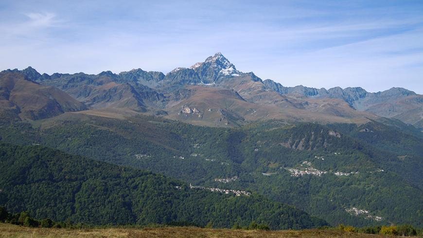
Orizzonte Monviso is a loop hike of unique beauty and variety.
Due to the richness of the environments, this itinerary is suitable for those in search of an extremely rewarding trek from many points of view: in fact, it offers endless cultural, artistic and environmental inspirations. Its precious pearl is the horizon that stands out like a painting in the eyes of those who start walking along it: the Monviso appears and disappears, and after a brief slope or on the opposite side presents itself with an unknown face, an unusual facet or color. Walking will be a continuous discovery and the relatively small difference in height in the itinerary will repay the length of some stages.
With this loop hike the hiker is given the opportunity to approach the world of the high lands of the Po Valley by following its paths and gradually discovering its thousand faces. The municipalities of Sanfront, Paesana, Oncino, Ostana and Crissolo, link the itinerary through a dense network of paths that touch villages and places far from the main well-known roads; well-tended and marked trails form an exciting loop hike in the presence of the Stone King.
Orizzonte Monviso is also an interesting opportunity for bikers with good physical preparation; the numerous dirt roads and mule tracks on which the route develops will certainly satisfy everyone's expectations. Most of the loop hike can in fact be ridden by bike with times and developments depending on the capacity and resistance of each person.
Recommended period
Accessible to people with disabilities
Support points
Hotels and tourist facilities in Sanfront, Paesana, Crissolo ed Ostana
Interest points
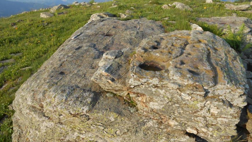
San Chiaffredo Sanctuary, in Crissolo; Ostana, one of the "Borghi più beli d'Italia" (most beautiful italian villages) and its ethnographic museum; Bric Lombatera's rock engravings, in Paesana, and Rocca La Casna's rock engravings, in Sanfront; The Po, the longest italian river; Monviso, the Cottian Alps highest mountain (3.841m.)
Dettagli
Profilo altimetrico
Dati tecnici
- Code
- OMV
- Classification
- Provincial - Mid and Low Altitude
- Local Tourist Agency (LTA) reference
- ATL del Cuneese - valli alpine e città d'arte
- Cell phone coverage
Good cell phone coverage in the city centres; less good in some itinerary's stretch.
- Country
- Italy
- Region
- Piemonte
- Province
- Cuneo
- Attachments
- Devotional relevance
- Sì
- Historical relevance
- Yes
- Ultima data di aggiornamento
- 15/12/2023
Altre info
Accommodation facilities

La colletta
- Località
PAESANA (CN)
Sud america
- Località
PAESANA (CN)
Valle po
- Località
PAESANA (CN)
'l ciabot
- Località
PAESANA (CN)
Club alpino
- Località
CRISSOLO (CN)
Visolotto
- Località
CRISSOLO (CN)
Da natale
- Località
PAESANA (CN)
La galaberna
- Località
OSTANA (CN)
A nostro mizoun
- Località
OSTANA (CN)
La via del sale
- Località
SANFRONT (CN)
Il bucaneve
- Località
CRISSOLO (CN)
Rifugio pian della regina
- Località
CRISSOLO (CN)
Centro culturale ricreativo con foresteria
- Località
OSTANA (CN)
Lou batent
- Località
OSTANA (CN)
Quarantaquattro
- Località
OSTANA (CN)
Le mulattiere
- Località
ONCINO (CN)
Alpino
- Località
PAESANA (CN)
Cascina bordiga
- Località
PAESANA (CN)
Rifugio bertorello
- Località
PAESANA (CN)
Il borgo
- Località
SANFRONT (CN)
Il mulino
- Località
SANFRONT (CN)
Resort monviso
- Località
SANFRONT (CN)
Rifugio miravidi
- Località
SANFRONT (CN)
Related apps
Trekviso
Escursionismo Piemonte: Terre del Monviso Itinerari escursionistici nelle valli del Cuneese: Po, Bronda, Varaita, Maira
Tappe
Tappe attività
-
0Orizzonte MonvisoLunghezza74.89 kmTempo1 day 2 hours 35 minutesDifficoltàHiking
-
1Stage 1: rif. esc. la via del sale - rif. esc. pian munèLunghezza15.88 kmTempo5 hours 45 minutesDifficoltàHiking
-
2Orizzonte Monviso - Tappa 2: Rif. esc. Pian Muné - Rif. esc. LossaLunghezza13.08 kmTempo3 hours 45 minutesDifficoltàHiking
-
2AStage 1a: paesana - bivio quota 1435Lunghezza8.84 kmTempo4 hours 10 minutesDifficoltàHiking
-
2BOrizzonte Monviso - Tappa 2A: Rif. Esc. Pian Muné - bivio Croce Tournour (Paesana)Lunghezza8.34 kmTempo3 hoursDifficoltàHiking
-
3Stage 3: rif. esc. lossa - crissoloLunghezza9.86 kmTempo3 hours 50 minutesDifficoltàHiking
-
4Stage 4: crissolo - rif. esc. la galabernaLunghezza5.90 kmTempo2 hours 15 minutesDifficoltàHiking
-
4AOrizzonte Monviso - Stage 4A: Crissolo - Borgo hamletLunghezza2.52 kmTempo1 hourDifficoltàHiking
-
5Stage 5: rif. esc. la galaberna - bg.ta ferrereLunghezza8.50 kmTempo3 hours 30 minutesDifficoltàHiking
-
6OMV Tappa 6: Borgata Ferrere - Località CollettaLunghezza9.81 kmTempo3 hours 20 minutesDifficoltàHiking
-
7Orizzonte Monviso - Tappa 7 Loc. Colletta - Rif. esc. La va del saleLunghezza11.86 kmTempo4 hours 10 minutesDifficoltàHiking