Galleria foto
- Lenght
- 99.50 km
- Tempo
- 1 day 15 hours 40 minutes
- Ascent elevation gain
- 3690 m
- Difficulty
- Hiking
- Itinerary index
- Yes
Informazioni
Punto di partenza
Ponte del Diavolo
10074 Lanzo Torinese TO
Italy
Punto di arrivo
Lago di Malciaussia
10070 Usseglio TO
Italy
Come arrivare
Access east: From Lanzo, at the entrance to Ponte del Diavolo Park, which can be easily reached both by public transport near the Lanzo station or Movicentro, and by car on the SP2.
Medium access: The route passes close to the villages and villages of Germagnano, Traves, Pessinetto, Mezzenile, Viù and Lemie. From all these places, depending on the hiker’s taste and after viewing the hiking map, you can find easy connections from where to take the route from the middle stages. Access west: From Usseglio, you drive to Malciaussia. Here starts the path n. 111B which goes down again in the direction of Usseglio taking advantage of the old route of the Deaucuville railway.
Descrizione
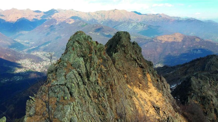
The hiking route TREK CALCANTE (TC) is so named because it is largely developed along the slopes of the Uja di Calcante, a very impressive peak that rises in the center of the Valleys of Lanzo that with its unique profile accompanies the panoramic views along the various stages of the itinerary. Starting from the Ponte del Diavolo Park of Lanzo, the route begins at medium low altitudes, and crosses the territory of Middle Valley, numerous villages, places of cultural and religious interest, woods and streams. In the intermediate stages it reaches higher altitudes, and encounters groups of alpine lakes, vast pastures active in the summer. The final stretch extends in the Valle di Viù. It extends among forest areas, panoramic parts, and in the final stage runs along the old railroad infrastructure decauville of the beginning‘900, which was used during the construction of the reservoirs and hydroelectric power plants. Thanks to the complex and varied nature of the route, the stage places offer very different opportunities. They consist partly of both small tourist and agritourist structures, with the typical architecture of the villages on the territory; from private Refuges that stand at the foot of the mountain pastures. For a most intense and adventurous experience, bivouacs, always open are available to hikers travelling in high mountain. The paths runs on marked trails or footpath and partly on a dirt road, that lead to alpine pastures, and on forest tracks. You can go along these tracks without any particular equipment, during the optimal period (May/June to October), but the length and height difference of some stages require a good training. Although the stages run from east to west, in a progressing increasing altitude, you can choose your direction of the itinerary, consider though that the tendency of the stretches is of greater ascent in the direction from east to west, while to the opposite one, the stages gradually reduce in intensity and fatigue required. This itinerary offers the possibility to connect and vary the route, putting together, for example, the starting point of Lanzo and the Anello Ceronda. This variation can become an alternative extension; while on the territory of Usseglio you can connect the GTA and with the tour of Alta Via delle Valli di Lanzo. For those who want to extend westward, they can rejoin to the Tour della Bessanese and France.
Recommended period
Accessible to people with disabilities
Itinerary suitable for disabled people.
Interest points
Ecomuseo Storia dell’Alpinismo delle Valli di Lanzo, Museo dell’Arte Tessile lanzese, Museo dell’utensileria Silmax, Antica strada per la Valle di Viù, Porta e Torre Civica di Aymone di Challant, Ponte del Diavolo, Centro documentazione storia contempo, Centro documentazione storia contemporanea e della resistenza "N. Grosa, Museo del Vino, Museo Etnografico degli Oggetti di Uso Quotidiano, Antica strada per la Valle di Viù, Punto Panoramico Monte Momello, Area didattica ambientale Giardinia, Sentiero del Calcante, Il sentiero Frassati di Traves, Sentiero dei Pellegrini, Sentiero del Treno, Castello dei Conti Francesetti, Ecomuseo dei Chiodaioli, Anello della Consolata, Li Pilon, Percorso Cicloturistico "Colle della Dieta", Uja di Calcante, Cascata La Gorgia di Mondrone, Ecomuseo della Resistenza, Museo Diffuso di Arte Sacra, Villa Franchetti, Parco Naturale del Colle del Lys, Cappella degli Olmetti, Ponte di Forno, Cappella di San Giulio, Anello delle religiosità di Lemie, Cascata torrente Ovarda, Il Bosco - Museo per tutti, Museo Civico Alpino “Arnaldo Tazzetti”, Mulino dei Vulpòt, Sentiero della Decauville.
Dettagli
Profilo altimetrico
Dati tecnici
- Code
- TKC
- Classification
- Provincial - Mid and Low Altitude
- Country
- Italy
- Region
- Piemonte
- Province
- Torino
- Attachments
- 2B_TC_ITALIANO.x33558.pdf
- Devotional relevance
- No
- Historical relevance
- Yes
- Ultima data di aggiornamento
- 15/12/2023
Altre info
Accommodation facilities

Structure qualification
Casa federico albert
Località
LANZO TORINESE (TO)
Structure qualification
Challant
Località
LANZO TORINESE (TO)
Structure qualification
Luigi bergera
Località
LANZO TORINESE (TO)
Structure qualification
Piemonte
Località
LANZO TORINESE (TO)
Structure qualification
Sangri-la'
Località
LANZO TORINESE (TO)
Structure qualification
Torino
Località
LANZO TORINESE (TO)
Structure qualification
Delle valli
Località
GERMAGNANO (TO)
Structure qualification
Lusiana
Località
TRAVES (TO)
Structure qualification
Ca' di spagna
Località
PESSINETTO (TO)
Structure qualification
Il mondo in valle
Località
PESSINETTO (TO)
Structure qualification
Alpe belvedere
Località
MEZZENILE (TO)
Structure qualification
Giardino dei marinai
Località
MEZZENILE (TO)
Structure qualification
Le lunelle
Località
MEZZENILE (TO)
Structure qualification
Istituto suore immacolatine
Località
MEZZENILE (TO)
Structure qualification
Ala
Località
ALA DI STURA (TO)
Structure qualification
Villa San Giuseppe
Località
ALA DI STURA (TO)
Structure qualification
Grand hotel ala di stura
Località
ALA DI STURA (TO)
Structure qualification
La crestolina
Località
ALA DI STURA (TO)
Structure qualification
Lungimala
Località
ALA DI STURA (TO)
Structure qualification
Raggio di sole
Località
ALA DI STURA (TO)
Structure qualification
Bertesseno
Località
VIÙ (TO)
Structure qualification
Casa per ferie madre enrichetta dominici
Località
VIÙ (TO)
Structure qualification
Colle del lys
Località
VIÙ (TO)
Structure qualification
Cottage graziella
Località
VIÙ (TO)
Structure qualification
Da norma
Località
VIÙ (TO)
Structure qualification
Il RUNCH
Località
VIÙ (TO)
Structure qualification
La comba
Località
VIÙ (TO)
Structure qualification
Lunella
Località
VIÙ (TO)
Structure qualification
Villa margherita
Località
LEMIE (TO)
Structure qualification
Bivacco San Camillo
Località
USSEGLIO (TO)
Structure qualification
Casa alpina San Vincenzo
Località
USSEGLIO (TO)
Structure qualification
Cibrario
Località
USSEGLIO (TO)
Structure qualification
Furnasa
Località
USSEGLIO (TO)
Structure qualification
Grand usseglio
Località
USSEGLIO (TO)
Structure qualification
Meuble' stella alpina
Località
USSEGLIO (TO)
Structure qualification
Nei et soleil
Località
USSEGLIO (TO)
Structure qualification
Rocciamelone
Località
USSEGLIO (TO)
Structure qualification
Tazzetti
Località
USSEGLIO (TO)
Structure qualification
Vulpot
Località
USSEGLIO (TO)
Tappe
Tappe attività
-
0Trek Calcante (TC)Lunghezza99.50 kmTempo1 day 15 hours 40 minutesDifficoltàHiking
-
1Trek Calcante: Stage 1 Lanzo T.se Ponte del Diavolo - TravesLunghezza14.00 kmTempo5 hoursDifficoltàHiking
-
2Trek Calcante: Stage 2 Traves - Frazione TornettiLunghezza18.40 kmTempo7 hours 40 minutesDifficoltàHiking
-
2ATrek Calcante: Stage 2A Colle Cialmetta (Bivacco) - Cappella della ConsolataLunghezza12.70 kmTempo6 hoursDifficoltàHiking
-
2BTrek Calcante: Stage 2B Cappella della Consolata - Alpe LongimalaLunghezza7.60 kmTempo4 hoursDifficoltàHiking
-
2CTrek Calcante: Stage 2C Alpe Longimala - Frazione TornettiLunghezza18.60 kmTempo7 hoursDifficoltàHiking
-
3Trek Calcante: Stage 3 Frazione Tornetti - Frazione Crot (Posto Tappa GTA)Lunghezza16.90 kmTempo6 hours 30 minutesDifficoltàHiking
-
4Trek Calcante: Stage 4 Frazione Crot (Posto Tappa GTA) - Lago di MalciaussiaLunghezza10.80 kmTempo3 hours 30 minutesDifficoltàHiking