Galleria foto
- Lenght
- 55.96 km
- Tempo
- 6 days
- Max altitude
- 2635 m
- Ascent elevation gain
- 3857 m
- Descent elevation loss
- 3857 m
- Difficulty
- Hiking
- Itinerary index
- Yes
Informazioni
Punto di partenza
Borgata Molè
10050 Coazze TO
Italy
Punto di arrivo
Borgata Molè
10050 Coazze TO
Italy
Come arrivare
The hamlet of Molè can be reached by a paved road from the Santuario in the village of Forno di Coazze (0.8 km.) and it is possible to park near the buildings. It is also possibly to park in the nearby square at the Santuario di Forno.
Descrizione
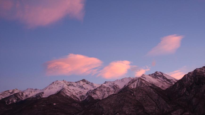
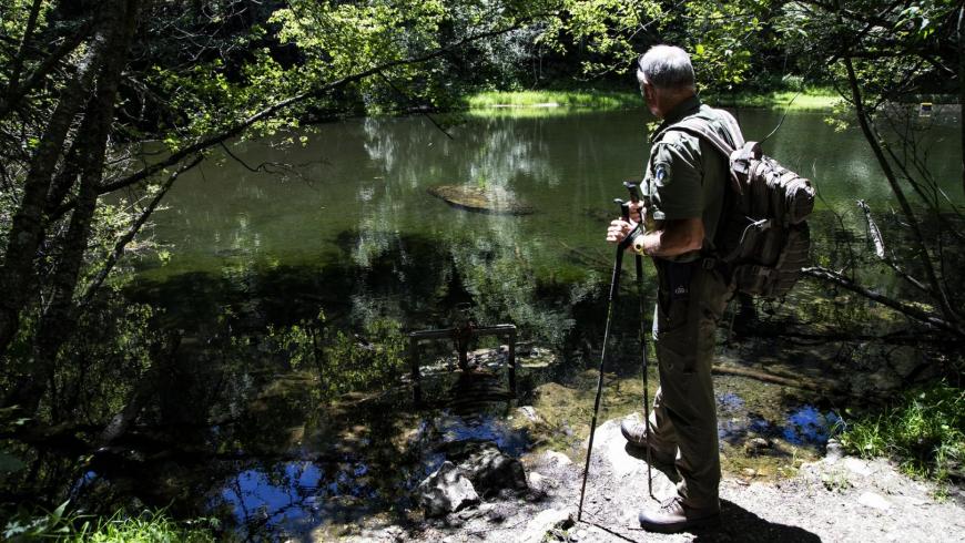
The Giro dell'Orsiera - GO Trail - is a 6-day hiking trail in the Parco Naturale Orsiera Rocciavrè. This is a circular walk of about 55 km with overnight stops available in 5 refuges which provide an excellent network of places to stay in order to better enjoy this challenging and exciting tour.
The departure and arrival point for the suggested stages is from the hamlet of Molè in the Municipality of Coazze (Val Sangone) and it is based on overnight stays in the following refuges Balma (1986 m), Selleries (2035 m), Toesca (1711 m), Amprimo (1375 m), GEAT Val Gravio (1376 m). The itinerary is suitable for any averagely-fit hiker, and any of the proposed stages can serve as a starting point. The trail is very versatile and many interesting variations are possible: you can use the old military trails to reach the refuges from the valleys and select only a few stages of your choice, or you can add to the itinerary by stopping several nights in a refuge and take advantage of the excellent network of hiking trails that criss-cross the area to make short excursions between one stage and another.
The G.O. runs along well-marked paths, with moderate gradients and frequent opportunities to stop in mountain shelters, on the shores of glacial lakes and in mountain pastures where you can taste local cheeses. However, it is essential to use a detailed and up-to-date hiking map.
The itinerary provides access to outstanding areas of uncontaminated nature just a stone's throw from Turin, and takes in a diverse range of different mountain environments, including alpine pastures, rocky high mountain terrain, larch and beech forests. With luck, hikers can spot chamois, deer, roe deer, wild boar, mouflon (a type of wild mountain sheep), ibex but also birdlife such as golden eagles, bearded vultures, kestrels, peregrine falcons and honey buzzards, mountain pheasants, partridges and rock partridges as well as minor fauna.
The trek also provides numerous opportunities for those curious to learn more about the history of the places. It passes through the Giro dell'Orsiera Trail, where there are many relics from medieval times (Certosa di Montebenedetto) and a great many small historical artefacts which provide insight into the lives of the shepherds and mountain folk who have populated these valleys for centuries (rock carvings, cobbled mule tracks, terraced slopes, rural hamlets, fountains and irrigation canals).
From the many panoramic viewpoints along the G.O., the views stretch to Superga, Rocca di Cavour, Monviso, the Po valley, the crystalline peaks of the Écrins mountain range, the Vanoise, the Rocciamelone and the Lake of Moncenisio.
The Giro dell’Orsiera Trail is an officially registered hike and is managed by the management authority Ente di gestione delle aree protette delle Alpi Cozie with the collaboration of the local municipalities it passes through (Bussoleno, Coazze, Mattie, Roure, San Giorio di Susa and Villar Focchiardo) and with the partnership of the Refuges situated along the Trail.
Recommended period
Accessible to people with disabilities
Support points
Rifugi Balma (1986 m), Selleries (2035 m), Toesca (1711 m), Amprimo (1375 m), GEAT Val Gravio (1376 m)
Bivacco fisso al Lago Laus (2274 m)
Rifugio non gestito all'Alpe Orsiera (1935 m)
Foresteria della Certosa di Montebenedetto (1149 m)
Interest points
Antichi alpeggi in cui si pratica la monticazione di bestiame bovino ed ovino, borgate montane con esempi di architettura spontanea e tracce delle passate attività tradizionali (mulattiere, terrazzamenti, canali d'irrigazione), Certosa di Montebenedetto (monastero certosino del XIII secolo, l'unico a conservare intatte le strutture medioevali).
Dettagli
Profilo altimetrico
Dati tecnici
- Code
- GDO
- Classification
- Provincial - High altitude
- Cell phone coverage
Buona copertura con qualche punto non servito.
- Country
- Italy
- Region
- Piemonte
- Province
- Torino
- Attachments
- GO-20Italiano-20v2018.pdf
- Approach elevation gain
- 0 m
- Other
L'itinerario è di tipo escursionistico ma si segnala un passaggio di grado EE (escursionistico per esperti) attrezzato con catene all'interno della Tappa 2: Rifugio Balma - Rifugio Selleries.
- Devotional relevance
- No
- Historical relevance
- Yes
- Ultima data di aggiornamento
- 15/12/2023
Tappe
Tappe attività
-
0The Giro dell'Orsiera G.O. TrailLunghezza55.96 kmTempo6 daysDifficoltàHiking
-
1The Giro dell'Orsiera G.O. Trail Stage 1: Molè - Rifugio BalmaLunghezza4.50 kmTempo2 hours 40 minutesDifficoltàHiking
-
2The Giro dell'Orsiera G.O. Trail Stage 2: Rifugio Balma - Rifugio SelleriesLunghezza9.16 kmTempo4 hours 25 minutesDifficoltàDifficult Hiking
-
3The Giro dell'Orsiera G.O. Trail Stage 3: Rifugio Selleries - Rifugio ToescaLunghezza6.71 kmTempo3 hours 10 minutesDifficoltàHiking
-
4The Giro dell'Orsiera G.O. Trail Stage 4: Rifugio Toesca - Rifugio AmprimoLunghezza13.13 kmTempo4 hours 20 minutesDifficoltàHiking
-
5The Giro dell'Orsiera G.O. Trail Stage 5: Rifugio Amprimo - Rifugio GEAT Val GravioLunghezza7.93 kmTempo2 hours 20 minutesDifficoltàHiking
-
6The Giro dell'Orsiera G.O. Trail Stage 6: Rifugio GEAT Val Gravio - MolèLunghezza14.53 kmTempo5 hours 20 minutesDifficoltàHiking