- Lenght
- 26.50 km
- Tempo
- 8 hours
- Tappa
- Max altitude
- 703 m
- Ascent elevation gain
- 1447 m
- Descent elevation loss
- 1009 m
- Difficulty
- Touristic
- Itinerary index
- No
Informazioni
Punto di partenza
Comune di Moncalieri
Cascina VALLERE
Corso Trieste 98 - Moncalieri
10024 Moncalieri TO
Italy
Punto di arrivo
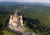
Basilica di Superga
Strada Basilica di Superga, 73
10132 Torino TO
Italy
Come arrivare
Descrizione
To the right of the Basilica of Superga, a board shows the paths of the routes to the east of Superga; From this point begins the route (n ° 26) downhill, which enters in the woods, and in a few hundred meters leads to the "curva del tabachin" at the Superga cooperative. It turns left onto the provincial road to Baldissero (itinerary no. 50). After passing the narrow passage between the houses of "Tetti Gioanin" the route leaves the ascent of the road of the hills (or "panoramic") to the right and continue towards Baldissero up to a large curve to the left (500 m) at the end of which, on the right, starts a dirt road that after a hairpin turn to the left meets, on the right, the path that reaches the "Bric del Duca" (671 meters). After, the route go down parallel to the panoramic up to a widening with a drinking water fountain (the "toret") from which you take, immediately on the left, the path that climbs to the top of the Bric San Giacomo (660 meters). From here on a steep descent, in the opposite direction to that of origin, you soon reach the road Palucco which after a while, still descending, passes to the south of the "Bric Palouch", now almost entirely dug by a gravel pit; continuing downhill the route skirts the quarry, wanders around what remains of the Bric and finally reaches the crossroads with the road to Valle Ceppi and the provincial road to Baldissero. Turn right now on the provincial road for about 450 meters, turn left on the road to Rivodora up to a crossroad (about 300 meters). Leaving the road, the route begins to go down to the right for road Croce, which after passing some villas is then reduced to dirt road. This is a beautiful route entirely in a wooded environment; after about a kilometer at a crossroads take a left and cross the ridge continuing on the north side for a short distance, after which you will find another path coming from the right marked with trail n. 51, on which the route continues in the direction of Cordova until it reaches the junction for Pavarolo on the right. The route crosses the villages of Pavarolo scattered on the ridges, from Tetti Varetto to Tetti San Defendente, then turns left on the asphalt road to Castiglione, after about a kilometer it contunues on the beautiful and scenic dirt road on the right that leads into the ancient hamlet of Bardassano, dominated by its mighty medieval castle. Crossed the village, it descends on the road that soon reaches the intersection of the provincial Castiglione / Chieri, better known as Strada della Rezza; on the opposite side of the intersection, the road to Sciolze begins (itinerary 150). The asphalted road runs entirely along the watershed that divides the Po plain to the north from the Chierese to the south. After a first flat stretch, the route climbs with tight bends in a chestnut wood to the junction of Collina Serra, from which it then continues towards Sciolze. Just before the false floor, on the left, you find the crossroads for Cascina Grosso, the route continues on the crest of the hill with a succession of stupendous panoramic views: on the left the Oltre Po plain, the Canavese, the imposing circle of the Alps with the Matterhorn and Monte Rosa; in front of the woods of Rivalba and Castagneto and in the distance Albugnano (the highest town in the Asti area); on the right the Chierese, the Langhe up to the Maritime Alps and, turning back, the Cozie Alps dominated by Monviso, the entrance to the Valle Susa and, closer, Superga and the Colle della Maddalena. After passing the junction for Tetti Bavento and the Palazzo farmhouse (both on the right) along the Colle di Fagnour, at the beginning of the descent towards Sciolze, just before a big trellis of Enel is the road closed by the bar, but a pedestrian passage leading to the hill and the stairway of the Park of Remembrance leading to the chapel of Santa Lucia (XI century). Continuing the descent, the route crosses the junction to Tetti Sachero on the left and shortly afterwards the junction for Montaldo on the right. The route then enters in Sciolze and crosses it in the direction of Rivalba - Cinzano along the walls of the castle and, after a short descent, it goes up again in the area "Rossetto" from which you can admire the panorama of Sciolze with its castle. After a wide curve you reach the crossroads "le Pere" (the stones) so called because it was marked by four stones (now there are only two due to the flooding of the road); they are big stone blocks on which the name of the donor of the road is engraved and the distances with the four terminal locations. Continuing uphill towards Cinzano the route enters the woods, with a few but majestic oaks and, after the umpteenth ascent between two banks of sediments and sandstone, it reaches a delightful flat stretch along a valley of meadows and vineyards open to the south-east. After a further stretch in the woods the route comes to a junction with a votive pillar called "Pilon dla Cadrega" from which you can see a stupendous view of Cinzano. Continuing on the crest of the very panoramic hill, a large semi-circle is made around the head of the Rio Brusà Valley, passing in front of the ancient church of San Desiderio and the route arrive shortly after the Gassino - Cinzano provincial junction at the "Croce del Gallo", a few hundred meters from the village of Cinzano, also dominated by its beautiful castle: In a few minutes you reach the pylon S. Antonio where the route continues on the road to the right to reach the town square, running from the right or from the left the castle park. After admiring the facade of the parish church and the ancient walls that support the castle garden, take Via Roma that leads to Moncucco. Follow the provincial road Cinzano - Moncucco up to the votive pillar located at the junction for Strada Torrazza where the itinerary n ° 144 (marked path) begins that leads to Vezzolano. From the junction, in a few hundred meters, the route reaches Torrazza hamlet and then descends, first on the asphalt road and then on a dirt road up to the provincial Torino-Asti, located downstream of the Cascina Morra. From this farm the route continues downhill on a narrow road just mentioned at the end of which it meets the provincial road Bersano / Castelnuovo. Cross the bridge over the Rio of Montana and face the ascent of Strada Pogliano / Betlemme which after a series of hairpin reaches Pogliano. Once here, turn left and continue on the route on a dirt road; after a flat stretch, starting up again, you can admire Cinzano, the Gran Paradiso massif, the castle and the plaster quarries of Moncucco. Just before reaching the Bethlehem farmhouse, take a left on the crest to the hill to get around the farmhouse; the route continues on a beautiful country road, to the left of which you can see a round boulder; continuing to rise, haze permitting, you can admire the chain of the Alps, from the Maritime to the Massif del Rosa and, on clear days, you can see the summit of the Matterhorn. The route is about to end: from the cross on the collar between the vineyards you are in sight of Albugnano and below, the beautiful abbey of Vezzolano built in the twelfth century, is now within walking distance. From the Abbey, go up to the town of Albugnano.
Recommended period
Accessible to people with disabilities
Dettagli
Profilo altimetrico
Dati tecnici
- Code
- SVC
- Classification
- Provincial - Mid and Low Altitude
- Local Tourist Agency (LTA) reference
- ATL Turismo Torino e Provincia
- Country
- Italy
- Region
- Piemonte
- Province
- Torino
- Devotional relevance
- Sì
- Historical relevance
- Yes
- Ultima data di aggiornamento
- 15/12/2023
Tappe
Tappe attività
-
0SVC - Superga - Vezzolano - CreaLunghezza115.00 kmTempo5 daysDifficoltàTouristic
-
1Superga Vezzolano Crea: Tappa 1 Basilica di Superga - AlbugnanoLunghezza26.50 kmTempo8 hoursDifficoltàTouristic
-
2Superga Vezzolano Crea: Tappa 2 Albugnano - MurisengoLunghezza25.30 kmTempo5 hoursDifficoltàHiking
-
3Superga Vezzolano Crea: Tappa 3 Murisengo - Santuario di CreaLunghezza20.60 kmTempo5 hoursDifficoltàHiking
-
4SVC TAPPA 4: Murisengo - Santuario Madonna di CreaLunghezza17.40 kmTempo4 hours 30 minutesDifficoltà
-
5SVC TAPPA 5: Santuario Madonna di Crea - Casale MonferratoLunghezza25.40 kmTempo7 hours 30 minutesDifficoltà

