Galleria foto
- Lenght
- 10.00 km
- Tempo
- 2 hours 15 minutes
- Tappa
Elenco risultati
- Ascent elevation gain
- 323 m
- Descent elevation loss
- 350 m
- Difficulty
- Hiking
- Itinerary index
- No
Informazioni
Punto di partenza
Albaretto della Torre
SP32 - Strada Provinciale 32
12050 Albaretto della Torre CN
Italy
Punto di arrivo
Benevello
Strada Comunale di Viale Langhe
12050 Benevello CN
Italy
Come arrivare
By car, motorways:
A6 – Torino Savona, Marene or Carmagnola exit
A21 – Torino Piacenza, Asti Est exit
A33 – Asti Cuneo, Alba exit
By plane:
Milano Malpensa and Linate – www.sea-aeroportimilano.it
Torino Caselle – www.aeroportoditorino.it
Cuneo Levaldigi – www.aeroporto.cuneo.it
By train:
Ferrovie dello Stato: www.trenitalia.com
Http://Www.grandabus.it/Tpl_orari.asp
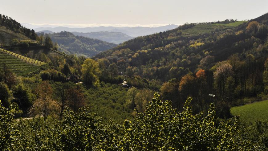
Descrizione
A hillcrest section that takes you to Pavaglione. This section features some stunning views and from Albaretto you can also head down in the opposite direction in a wide circle to switch valleys and reach the other crest of the GTL.
As you leave Albaretto della Torre in the direction of Tre Cunei, this route passes right in front of “Botega ‘d Cesare”, right across from the church of San Bernardo, before you climb up to the left to Strada Fontanassino. This narrow street, which is closed to traffic and adorned with the Stages of the Cross, winds past the fountain, for which it is named, to the hillcrest highway. Watch for cars and follow the highway to the left. At the midpoint of the next straight, head down again to the left on a narrow, paved road (signage for Cascina Corylicola). Continue along a flat, gravel road through the hazelnut trees and pass a spring with a lovely cut of rock, before you reach a farmhouse. The road turns to dirt and continues slightly downward through the grass before rising up through a couple of switchbacks to the hamlet of Burdia. Here, a plaque indicates the birthplace of the famous violin maker, Giovanni Pressenda, who left this stone farmhouse to go to Turin, where he would make sublime, now unobtainable violins.
A lovely but steep gravel road will take you back to the hillcrest highway near the crossroads for Benevello, where the Serravalle-Cerretto-ArguelloLequio Berria detour also joins up with the main itinerary. Cross the highway and follow the signs for Benevello. Leave the paved road at the first crossroads and head up to the left along a gravel road. Follow along the panoramic hillcrest past an aqueduct depot and then down to a saddle in the hill. From here, you will leave the crest and descend gradually along the dirt road to the left through the hazelnut groves to the paved road near the farmhouse Pian dei Gatti.
Continue to the left and follow along the main highway for about 600 metres (less than half a mile) to an intersection in the flat. From here, turn right and head back up a somewhat faint dirt road along the crest of the hill. The road will become more evident and continue along or near the crest. This panoramic section will take you back to the main highway near the village of Belmondo and the church of Madonna di Langa. You will need to follow the highway again for a couple of kilometres (a bit more than a mile) to the first homes in Benevello. A fork to the right will take you up a final climb to the village’s square and castle.
In Benevello, the austere castle with its two circular towers (now a privately owned building) protects the lovely Church of San Pietro in Vincoli, which is surrounded by a cool, steep garden with a view. The handful of narrow streets in the village are well worth a leisurely stroll.
Recommended period
Accessible to people with disabilities
Interest points
Benevello : Chiesa Parrocchiale di San Pietro in Vincoli , Chiesa della Madonna di Langa .
Albaretto della Torre : Tower , Chiesa di San Bernardo .
Dettagli
Profilo altimetrico
Dati tecnici
- Code
- GTL
- Classification
- Provincial - Mid and Low Altitude
- Local Tourist Agency (LTA) reference
- ATL Langhe Monferrato Roero
- Country
- Italy
- Region
- Piemonte
- Province
- Cuneo
- Devotional relevance
- No
- Historical relevance
- No
- Ultima data di aggiornamento
- 15/12/2023
Altre info
Accommodation facilities

Structure qualification
Al brich
Località
ALBARETTO DELLA TORRE (CN)
Structure qualification
La corte di LANGA
Località
ALBARETTO DELLA TORRE (CN)
Structure qualification
Le vigne
Località
BENEVELLO (CN)
Structure qualification
Relais villa d'amelia
Località
BENEVELLO (CN)
Tappe
Tappe attività
-
0GTL - Grande Traversata delle LangheLunghezza240.00 kmTempo2 days 4 hoursDifficoltàHiking
-
1GTL - Grande Traversata delle Langhe - Leg 1: Castino - CortemiliaLunghezza8.50 kmTempo2 hoursDifficoltàHiking
-
1AGTL - Grande Traversata delle Langhe - Leg 1A: Castino - Santo Stefano BelboLunghezza14.30 kmTempo4 hoursDifficoltàHiking
-
2GTL - Grande Traversata delle Langhe - Leg 2: Cortemilia - BergoloLunghezza5.20 kmTempo1 hour 30 minutesDifficoltàHiking
-
2AGTL - Grande Traversata delle Langhe - Leg 2A: Pezzolo Valle Uzzone - Santuario del TodoccoLunghezza5.50 kmTempo1 hour 35 minutesDifficoltàHiking
-
2BGTL - Grande Traversata delle Langhe - Leg 2B: Cortemilia - Bric della Croce (Perletto)Lunghezza5.00 kmTempo1 hour 45 minutesDifficoltàTouristic
-
3GTL - Grande Traversata delle Langhe - Leg 3: Bergolo - PrunettoLunghezza9.20 kmTempo2 hours 40 minutesDifficoltàHiking
-
3AGTL - Grande Traversata delle Langhe - Leg 3A: Bergolo - Pezzolo Valle UzzoneLunghezza3.10 kmTempo35 minutesDifficoltàHiking
-
3BGTL - Grande Traversata delle Langhe - Leg 3B: Bergolo - Torre BormidaLunghezza6.20 kmTempo1 hour 25 minutesDifficoltàHiking
-
4GTL - Grande Traversata delle Langhe - Leg 4: Prunetto - GottaseccaLunghezza7.50 kmTempo2 hours 10 minutesDifficoltàHiking
-
4AGTL - Grande Traversata delle Langhe - Leg 4A: Prunetto - MonesiglioLunghezza9.70 kmTempo2 hours 5 minutesDifficoltàHiking
-
4BGTL - Grande Traversata delle Langhe - Leg 4B: Monesiglio - Bricco Ronchetto (Mombarcaro)Lunghezza4.50 kmTempo1 hour 30 minutesDifficoltàHiking
-
5GTL - Grande Traversata delle Langhe - Leg 5: Gottasecca - SalicetoLunghezza11.50 kmTempo3 hours 35 minutesDifficoltàHiking
-
5AGTL - Grande Traversata delle Langhe - Leg 5A: Gottasecca - Ligurian BorderLunghezza5.00 kmTempo1 hourDifficoltàHiking
-
6GTL - Grande Traversata delle Langhe - Leg 6: Saliceto - MombarcaroLunghezza19.00 kmTempo6 hoursDifficoltàHiking
-
7GTL - Grande Traversata delle Langhe - Leg 7: Mombarcaro - San Benedetto BelboLunghezza4.50 kmTempo1 hour 20 minutesDifficoltàHiking
-
7AGTL - Grande Traversata delle Langhe - Leg 7A: San Benedetto Belbo - MurazzanoLunghezza5.50 kmTempo1 hour 45 minutesDifficoltàHiking
-
8GTL - Grande Traversata delle Langhe - Leg 8: Murazzano - BossolascoLunghezza10.00 kmTempo2 hours 45 minutesDifficoltàTouristic
-
9GTL - Grande Traversata delle Langhe - Leg 9: Bossolasco - Serravalle LangheLunghezza6.00 kmTempo1 hour 45 minutesDifficoltàHiking
-
9AGTL - Grande Traversata delle Langhe - Leg 9A: Serravalle Langhe - Cerretto LangheLunghezza7.50 kmTempo1 hour 50 minutesDifficoltàHiking
-
9BGTL - Grande Traversata delle Langhe - Leg 9B: Cerreto Langhe - ArguelloLunghezza4.50 kmTempo50 minutesDifficoltàHiking
-
9CGTL - Grande Traversata delle Langhe - Leg 9C: Arguello - Lequio BerriaLunghezza4.50 kmTempo1 hour 25 minutesDifficoltàHiking
-
9DGTL - Grande Traversata delle Langhe - Leg 9D: Lequio Berria - BenevelloLunghezza8.00 kmTempo2 hours 10 minutesDifficoltàHiking
-
10GTL - Grande Traversata delle Langhe - Leg 10: Serravalle Langhe - Albaretto della TorreLunghezza5.80 kmTempo1 hour 45 minutesDifficoltàHiking
-
11GTL - Grande Traversata delle Langhe - Leg 11: Albaretto della Torre - BenevelloLunghezza10.00 kmTempo2 hours 15 minutesDifficoltàHiking
-
12GTL - Grande Traversata delle Langhe - Leg 12: Benevello - PavaglioneLunghezza4.70 kmTempo1 hour 30 minutesDifficoltàHiking
-
13GTL - Grande Traversata delle Langhe - Leg 13: Pavaglione - CastinoLunghezza7.70 kmTempo2 hours 30 minutesDifficoltàTouristic
-
13AGTL - Grande Traversata delle Langhe - Leg 13A: Pavaglione - S. DonatoLunghezza13.70 kmTempo4 hoursDifficoltàDifficult Hiking
-
14GTL - Grande Traversata delle Langhe - Leg 14: Castino - CravanzanaLunghezza7.00 kmTempo2 hours 30 minutesDifficoltàHiking
-
15GTL - Grande Traversata delle Langhe - Leg 15: Cravanzana - FeisoglioLunghezza5.50 kmTempo1 hour 45 minutesDifficoltàHiking
-
15AGTL - Grande Traversata delle Langhe - Leg 15A: Cravanzana - Torre BormidaLunghezza2.80 kmTempo45 minutesDifficoltàHiking
-
15BGTL - Grande Traversata delle Langhe - Leg 15B: Bric del Cucco (Cravanzana) - Torre BormidaLunghezza5.70 kmTempo1 hour 50 minutesDifficoltàTouristic
-
16GTL - Grande Traversata delle Langhe - Leg 16: Feisoglio - Niella BelboLunghezza5.40 kmTempo1 hour 45 minutesDifficoltàHiking
-
16AGTL - Grande Traversata delle Langhe - Leg 16A: Bricco San Michele (Serravalle Langhe) - FeisoglioLunghezza5.10 kmTempo1 hour 45 minutesDifficoltàHiking
-
17GTL - Grande Traversata delle Langhe - Leg 17: Niella Belbo - San Benedetto BelboLunghezza5.50 kmTempo1 hour 20 minutesDifficoltàHiking