Galleria foto
- Lenght
- 11.50 km
- Tempo
- 3 hours 35 minutes
- Tappa
Elenco risultati
- Ascent elevation gain
- 328 m
- Descent elevation loss
- 630 m
- Difficulty
- Hiking
- Itinerary index
- No
Informazioni
Punto di partenza
Gottasecca
Via Ravina, 44
12070 Gottasecca CN
Italy
Punto di arrivo
Saliceto
Via dei Fossi
12079 Saliceto CN
Italy
Come arrivare
By car, motorways:
A6 – Torino Savona, Marene or Carmagnola exit
A21 – Torino Piacenza, Asti Est exit
A33 – Asti Cuneo, Alba exit
By plane:
Milano Malpensa and Linate – www.sea-aeroportimilano.it
Torino Caselle – www.aeroportoditorino.it
Cuneo Levaldigi – www.aeroporto.cuneo.it
By train:
Ferrovie dello Stato: www.trenitalia.com
Http://Www.grandabus.it/Tpl_orari.asp
Descrizione
A route near the border with Liguria, the culture of which can be sensed in the villages here.
The starting point is Gottasecca, where there are the remains of an ancient castle, including what’s left of its tower and part of its outer wall. Certainly worth a look is the bust of Ravina, a poet and patriot of the fight for Italian unification who was born here two centuries ago, as is the main street of town that winds from the main church down through the houses and on to the main highway.
From the square, head past the main church down along the paved road that crosses the entire historical centre of town. Cross the main road and follow the signs for the sanctuary (santuario) up to the last house in town. The marked route passes behind the house to the right. After a brief climb, turn left and head down gradually to remain below the crest of the hill. Pass a lovely fountain and a few houses, then turn left. The road will be paved again when you reach a curve. Turn right onto a steep, downward sloping road to the ample clearing that surrounds the Santuario della Madonna Assunta, which was erected in place of the ancient Parish of Santa Maria di Gudega and is a stunning example of 17th century architecture with its nave and two aisles and its eight-strips façade looking out over the valley. The adjacent Casa del Pellegrino offers shelter for all travellers.
You will now need to retrace your steps for a few metres and, rather than climbing, head along the flat to the right on a dirt road into the woods. An initial curve to the left and another to the right will take you across a small stream. Head up to the left at the next fork in the road near a field and continue on to the crest of the hill. Pass a few fields and head back into the woods, which will be dense with downy oak. After a final climb, you will reach the crest, where the trail continues along a false flat. The ups and downs of this trail continue until a marked descent to the left, which is often muddy. Turn right at a crossroads and continue along the flat to a characteristic selletta (saddle).
Continue down to the left along a gravel road until you reach, after a brief uphill, a paved road at an intersection known as “Le Quattro Vie” (The Four Roads), where you will see a shrine. Cross the paved road and, just a few metres to the left, take the trail that heads up into the woods. A few stone “steps” cut by water erosion make this section more difficult. You will soon reach the crest of the hill, where you will need to follow a wide dirt trail that runs slightly uphill as it cuts across the summit of Bric Baraccone until you reach a clearing. Here, you are at the extreme edge of the Piedmont region at the border with Liguria (and it is here that the Uzzone river begins).
Head to the right and continue until another wayside shrine uphill from the Baraccone farmhouse in the middle of vast pasturelands. Continue along the crest until the paved road, then follow this road for a few dozen metres until you find a curve into the woods. Continuing along the crest and the dirt road to the left, you will reach a panoramic intersection in the middle of vast cultivated fields. Keep to the centre along the watershed as the dirt road gradually reenters the woods and, after a stony uphill section, becomes more gravelly.
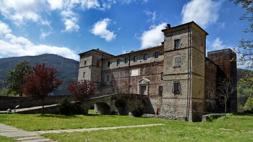
Continue to the right and then, after the “La Madonnina” shrine at a characteristic rock outcropping, along a flat section until the end of the gravel road near a number of farmhouses. Once on the paved road, you will head down, past a number of wide curves, to the first homes of the village of Saliceto. Turn right at the end of the descent and continue along the flat alongside the town park. You will soon come to the main highway of the Bormida Valley. Turn left here and head to the square. Saliceto is a lovely valley village with evident Ligurian influences, including a picturesque Renaissance castle built on the banks of the Bormida as well as a number of remarkable churches, featuring the Church of San Lorenzo, a masterpiece of Donato Bramante, like its cousin the Church of Roccaverano, which has a number of esoteric symbols in its façade, including a rare Baphomet (which connects the church to the legends of the Templars). Then there is the Sant’Agostino Oratory with its rare portrayal of St. Francis in the Bormida Valley and other traditional subjects of religious art. Finally, there is the hidden masterpiece of the Church of San Martino in Lignera, which is certain to take your breath away just as it has done to travellers of these valleys for centuries, as they witnessed the extraordinary 15th century frescoes of the nearby Mondovì school.
Recommended period
Accessible to people with disabilities
Interest points
Gottasecca : Pieve di Santa Maria , Sanctuary of Maria Vergine Assunta , Sanctuary of Madonna della Neve .
Saliceto : Chiesa di San Martino di Lignera , Chiesa di San Lorenzo , Castle of Marchesi del Carretto .
Camerana : Medieval Tower .
Dettagli
Profilo altimetrico
Dati tecnici
- Code
- GTL
- Classification
- Provincial - Mid and Low Altitude
- Local Tourist Agency (LTA) reference
- ATL Langhe Monferrato Roero
- Country
- Italy
- Region
- Piemonte
- Province
- Cuneo
- Devotional relevance
- No
- Historical relevance
- No
- Ultima data di aggiornamento
- 15/12/2023
Altre info
Accommodation facilities

Structure qualification
La mesa verde
Località
SALICETO (CN)
Structure qualification
Casa martini
Località
SALICETO (CN)
Structure qualification
Sorgenti del belbo
Località
SALICETO (CN)
Structure qualification
Ca' veja
Località
GOTTASECCA (CN)
Tappe
Tappe attività
-
0GTL - Grande Traversata delle LangheLunghezza240.00 kmTempo2 days 4 hoursDifficoltàHiking
-
1GTL - Grande Traversata delle Langhe - Leg 1: Castino - CortemiliaLunghezza8.50 kmTempo2 hoursDifficoltàHiking
-
1AGTL - Grande Traversata delle Langhe - Leg 1A: Castino - Santo Stefano BelboLunghezza14.30 kmTempo4 hoursDifficoltàHiking
-
2GTL - Grande Traversata delle Langhe - Leg 2: Cortemilia - BergoloLunghezza5.20 kmTempo1 hour 30 minutesDifficoltàHiking
-
2AGTL - Grande Traversata delle Langhe - Leg 2A: Pezzolo Valle Uzzone - Santuario del TodoccoLunghezza5.50 kmTempo1 hour 35 minutesDifficoltàHiking
-
2BGTL - Grande Traversata delle Langhe - Leg 2B: Cortemilia - Bric della Croce (Perletto)Lunghezza5.00 kmTempo1 hour 45 minutesDifficoltàTouristic
-
3GTL - Grande Traversata delle Langhe - Leg 3: Bergolo - PrunettoLunghezza9.20 kmTempo2 hours 40 minutesDifficoltàHiking
-
3AGTL - Grande Traversata delle Langhe - Leg 3A: Bergolo - Pezzolo Valle UzzoneLunghezza3.10 kmTempo35 minutesDifficoltàHiking
-
3BGTL - Grande Traversata delle Langhe - Leg 3B: Bergolo - Torre BormidaLunghezza6.20 kmTempo1 hour 25 minutesDifficoltàHiking
-
4GTL - Grande Traversata delle Langhe - Leg 4: Prunetto - GottaseccaLunghezza7.50 kmTempo2 hours 10 minutesDifficoltàHiking
-
4AGTL - Grande Traversata delle Langhe - Leg 4A: Prunetto - MonesiglioLunghezza9.70 kmTempo2 hours 5 minutesDifficoltàHiking
-
4BGTL - Grande Traversata delle Langhe - Leg 4B: Monesiglio - Bricco Ronchetto (Mombarcaro)Lunghezza4.50 kmTempo1 hour 30 minutesDifficoltàHiking
-
5GTL - Grande Traversata delle Langhe - Leg 5: Gottasecca - SalicetoLunghezza11.50 kmTempo3 hours 35 minutesDifficoltàHiking
-
5AGTL - Grande Traversata delle Langhe - Leg 5A: Gottasecca - Ligurian BorderLunghezza5.00 kmTempo1 hourDifficoltàHiking
-
6GTL - Grande Traversata delle Langhe - Leg 6: Saliceto - MombarcaroLunghezza19.00 kmTempo6 hoursDifficoltàHiking
-
7GTL - Grande Traversata delle Langhe - Leg 7: Mombarcaro - San Benedetto BelboLunghezza4.50 kmTempo1 hour 20 minutesDifficoltàHiking
-
7AGTL - Grande Traversata delle Langhe - Leg 7A: San Benedetto Belbo - MurazzanoLunghezza5.50 kmTempo1 hour 45 minutesDifficoltàHiking
-
8GTL - Grande Traversata delle Langhe - Leg 8: Murazzano - BossolascoLunghezza10.00 kmTempo2 hours 45 minutesDifficoltàTouristic
-
9GTL - Grande Traversata delle Langhe - Leg 9: Bossolasco - Serravalle LangheLunghezza6.00 kmTempo1 hour 45 minutesDifficoltàHiking
-
9AGTL - Grande Traversata delle Langhe - Leg 9A: Serravalle Langhe - Cerretto LangheLunghezza7.50 kmTempo1 hour 50 minutesDifficoltàHiking
-
9BGTL - Grande Traversata delle Langhe - Leg 9B: Cerreto Langhe - ArguelloLunghezza4.50 kmTempo50 minutesDifficoltàHiking
-
9CGTL - Grande Traversata delle Langhe - Leg 9C: Arguello - Lequio BerriaLunghezza4.50 kmTempo1 hour 25 minutesDifficoltàHiking
-
9DGTL - Grande Traversata delle Langhe - Leg 9D: Lequio Berria - BenevelloLunghezza8.00 kmTempo2 hours 10 minutesDifficoltàHiking
-
10GTL - Grande Traversata delle Langhe - Leg 10: Serravalle Langhe - Albaretto della TorreLunghezza5.80 kmTempo1 hour 45 minutesDifficoltàHiking
-
11GTL - Grande Traversata delle Langhe - Leg 11: Albaretto della Torre - BenevelloLunghezza10.00 kmTempo2 hours 15 minutesDifficoltàHiking
-
12GTL - Grande Traversata delle Langhe - Leg 12: Benevello - PavaglioneLunghezza4.70 kmTempo1 hour 30 minutesDifficoltàHiking
-
13GTL - Grande Traversata delle Langhe - Leg 13: Pavaglione - CastinoLunghezza7.70 kmTempo2 hours 30 minutesDifficoltàTouristic
-
13AGTL - Grande Traversata delle Langhe - Leg 13A: Pavaglione - S. DonatoLunghezza13.70 kmTempo4 hoursDifficoltàDifficult Hiking
-
14GTL - Grande Traversata delle Langhe - Leg 14: Castino - CravanzanaLunghezza7.00 kmTempo2 hours 30 minutesDifficoltàHiking
-
15GTL - Grande Traversata delle Langhe - Leg 15: Cravanzana - FeisoglioLunghezza5.50 kmTempo1 hour 45 minutesDifficoltàHiking
-
15AGTL - Grande Traversata delle Langhe - Leg 15A: Cravanzana - Torre BormidaLunghezza2.80 kmTempo45 minutesDifficoltàHiking
-
15BGTL - Grande Traversata delle Langhe - Leg 15B: Bric del Cucco (Cravanzana) - Torre BormidaLunghezza5.70 kmTempo1 hour 50 minutesDifficoltàTouristic
-
16GTL - Grande Traversata delle Langhe - Leg 16: Feisoglio - Niella BelboLunghezza5.40 kmTempo1 hour 45 minutesDifficoltàHiking
-
16AGTL - Grande Traversata delle Langhe - Leg 16A: Bricco San Michele (Serravalle Langhe) - FeisoglioLunghezza5.10 kmTempo1 hour 45 minutesDifficoltàHiking
-
17GTL - Grande Traversata delle Langhe - Leg 17: Niella Belbo - San Benedetto BelboLunghezza5.50 kmTempo1 hour 20 minutesDifficoltàHiking