- Lenght
- 14.00 km
- Tempo
- 3 hours 20 minutes
- Tappa
- Descent elevation loss
- 109 m
- Difficulty
- Touristic
- Itinerary index
- No
Informazioni
Punto di partenza
Cisterna d'Asti
Piazza Hope
14010 Cisterna d'Asti AT
Italy
Punto di arrivo
Castelvecchio
14012 Ferrere AT
Italy
Come arrivare
Descrizione
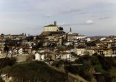
The itinerary, the Via dei Briganti, starts from the concentric of Cisterna d'Asti, dominated by the castle, whose first structure dates back to the 11th century and gradually expanded and embellished over the following centuries. Currently it houses the Museum of Arts and Crafts of the past. The itinerary then takes place in a first stretch along the ordinary road network of the concentric. Near via Pranzovero, the itinerary plunges into the woods surrounding the area to descend into the valley and climb up to the hamlet of Saretto. After crossing the small village, we continue north-east, through woods and vegetation, in a not very man-made environment, until we arrive at the San Damiano farmhouse and, a little further away, at the Scaglie hamlet, now inhabited by very few people and, at one time, an important agricultural centre on this ridge. The path continues, gradually lowering until it reaches the provincial road, where there is the church of the Vattigliera. From here, again through a beautiful forest, you go up to the road of the hamlet of San Giuseppe, where there is a small church of nineteenth-century plant and recently restored. The paved municipal road with low traffic intensity crosses the hamlet of San Giuseppe and gradually descends the hill until it intersects with the road Gherba. After about 300 m along this road, you arrive at the end of stage 1. You can then choose to take stage 2 that leads to Villafranca d'Asti or take the ancient Via dei Morti, variant 1B, so called because it was the road that connected the historic center of Ferrere with the cemetery. This road allows you to go back to the historical part of Ferrere, and, therefore, to the Town Hall Square near Castelvecchio and the nearby guesthouse of Casa Carolina.
Recommended period
Accessible to people with disabilities
Dettagli
Profilo altimetrico
Dati tecnici
- Code
- VBR
- Classification
- Provincial - Mid and Low Altitude
- Country
- Italy
- Region
- Piemonte
- Province
- Asti
- Devotional relevance
- No
- Historical relevance
- No
- Ultima data di aggiornamento
- 15/12/2023
Altre info
Accommodation facilities

Garibaldi
- Località
CISTERNA D'ASTI (AT)

Grotto valle
- Località
CISTERNA D'ASTI (AT)

La serra
- Località
CISTERNA D'ASTI (AT)

Le betulle
- Località
CISTERNA D'ASTI (AT)

Tenuta la pergola
- Località
CISTERNA D'ASTI (AT)

Cascina monticone
- Località
FERRERE (AT)

Castelvecchio
- Località
FERRERE (AT)

Cascina papa mora
- Località
CELLARENGO (AT)
Tappe
Tappe attività
-
-
1Via dei Briganti: Tappa 1 Cisterna d'Asti - FerrereLunghezza14.00 kmTempo3 hours 20 minutesDifficoltàTouristic
-
1AVia dei Briganti: Tappa 1A Cisterna d'Asti Loc. Valle Oscura - Area attrezzataLunghezza1.20 kmTempo25 minutesDifficoltàTouristic
-
1BVia dei Briganti: Tappa 1B Bivio tappa 1 - Ferrere centro storicoLunghezza1.70 kmTempo25 minutesDifficoltàTouristic
-
2Via dei Briganti: Tappa 2 Ferrere - Villafranca d'AstiLunghezza14.00 kmTempo3 hours 35 minutesDifficoltàTouristic
-
3Via dei Briganti: Tappa 3 Villafranca d'Asti - RoattoLunghezza12.00 kmTempo2 hours 25 minutesDifficoltàTouristic
-
3AVia dei Briganti: Tappa 3A: San Paolo Solbrito - Cascina SabbioneLunghezza7.20 kmTempo2 hours 25 minutesDifficoltàTouristic
-
3BVia dei Briganti: Tappa 3B Roatto - Frazione PangeriLunghezza1.80 kmTempo40 minutesDifficoltàTouristic


