Galleria foto
- Lenght
- 0.80 km
- Tempo
- 20 minutes
- Tappa
Elenco risultati
- Max altitude
- 1860 m
- Ascent elevation gain
- 30 m
- Descent elevation loss
- 30 m
- Difficulty
- Touristic
- Itinerary index
- No
Informazioni
Punto di partenza
Bivio tappa 1 - Parcheggio Grange della Valle
10050 Exilles TO
Italy
Punto di arrivo
Rifugio Levi-Molinari
10050 Exilles TO
Italy
Come arrivare
In Auto: SS24 fino a Salbertrand, bivio per Grange della Valle, seguire fino a parcheggio presso Rifugio Levi-Molinari (poi 10 minuti a piedi)
Descrizione
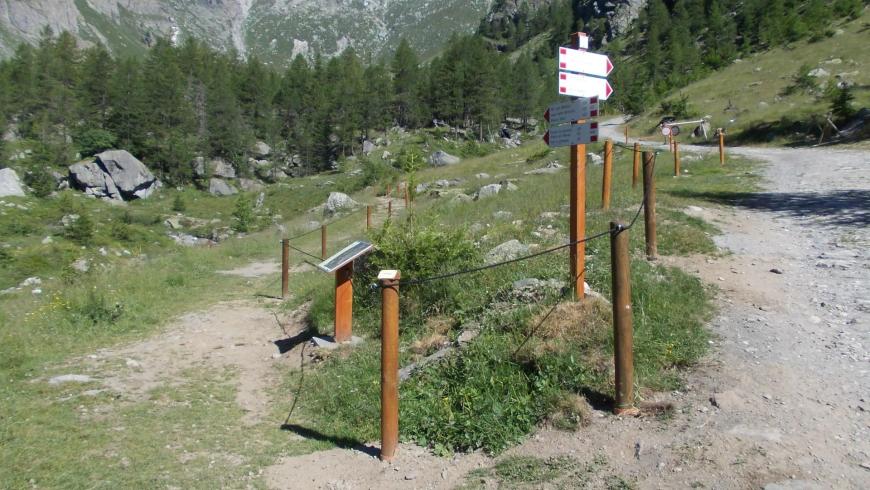
This circular themed educational path is suitable for visually impaired people and is located near Rifugio Levi Molinari (which serves as a reference and starting point). The route is self-guided, and assisted by the presence along the route of a rope handrail supported by wooden poles and waymarkings. Themed points of interest have been set up to educate walkers about local cultural and environmental issued. They are based around sensory perception: 4 panels and 2 wooden totems are set up along the circular route in such a way as to enable people to discover information about the local area using images for their hands and using tactile, auditory, olfactory and gustatory exploration. Right from the start of the route, panels with Braille inscriptions have been positioned along the forest access road to the refuge to present and enable tactile exploration of the path, of some forest species, for the presentation of information about the the natural environment, surrounding area and endemic fauna. The sense of hearing is stimulated through stages along the path aimed at encouraging walkers to recognize different types of water courses (brooks, streams and waterfalls), and it is also possible to appreciate other sounds of nature in the less frequented and sites further away from the refuge (birdsong, and in autumn the call of deer etc.). At the centre of the meadow in front of the refuge there are two totems that present two typical alpine activities, through images and texts in Braille and in plain text, as well as the presence of objects that are designed to focus on the sense of touch, namely, wood sculptures and rock climbing. And so on for other information points along the route that ends near the intersection with the path that goes up to Col d'Ambin, where a large rock is situated which visitors can boulder on, thus enabling them to try out the sport of climbing. At the refuge, in collaboration with the manager, it is also possible to organize tastings of typical local products (including cheeses of different maturities, honey, etc.), associating the available products to their origin and production method. There are personnel at Rifugio Levi Molinari who have been specially trained to assist disabled and visually impaired people and thus guarantee correct management of the path and of the educational activities connected to it.
Recommended period
Accessible to people with disabilities
Sentiero attrezzato per persone ipovedenti.
Support points
Rifugio Levi - Molinari
Dettagli
Profilo altimetrico
Dati tecnici
- Code
- TAM
- Classification
- Provincial - High altitude
- Cell phone coverage
Discreta
- Country
- Italy
- Region
- Piemonte
- Province
- Torino
- Devotional relevance
- No
- Historical relevance
- No
- Ultima data di aggiornamento
- 15/12/2023
Altre info
Accommodation facilities

Structure qualification
Levi molinari
Località
EXILLES (TO)
Tappe
Tappe attività
-
0TAM - Tour d'AmbinLunghezza57.10 kmTempo5 daysDifficoltàDifficult Hiking
-
1Tour d'Ambin Trail: Stage 1 San Colombano - Rifugio Ambin (France)Lunghezza10.10 kmTempo7 hours 10 minutesDifficoltàDifficult Hiking
-
1ATour d'Ambin Trail: Stage 1A Grange della Valle - Rifugio Levi-Molinari (circular route)Lunghezza0.80 kmTempo20 minutesDifficoltàTouristic
-
2Tour d'Ambin Trail: Stage 2 Rifugio Ambin (France) - Rifugio VaccaroneLunghezza19.00 kmTempo7 hoursDifficoltàDifficult Hiking
-
2ATour d'Ambin Trail: Stage 2A Col Clapier - Bivacco Clapier mountain shelterLunghezza0.40 kmTempo15 minutesDifficoltàHiking
-
3TAM Tappa 3: Rifugio Vaccarone - Rifugio Levi-MolinariLunghezza8.60 kmTempo6 hoursDifficoltàHiking
-
3ATour d'Ambin Trail: Stage 3A Lago del Gias - Grange della ValleLunghezza11.20 kmTempo5 hoursDifficoltàHiking
-
4Tour d'Ambin Trail: Stage 4 Levi-Molinari Hut - Bivacco Sigot mountain shelterLunghezza5.60 kmTempo4 hours 30 minutesDifficoltàDifficult Hiking
-
5Tour d'Ambin Trail: Stage 5 Bivacco Sigot mountain shelter - RochemollesLunghezza13.80 kmTempo4 hours 30 minutesDifficoltàHiking
-
5ATour d'Ambin Trail: Stage 5A Passo Galambra - Grange ValfreddaLunghezza7.70 kmTempo4 hours 30 minutesDifficoltàHiking
-
5BTour d'Ambin Trail: Stage 5B Pramand Barracks - OulxLunghezza9.70 kmTempo4 hoursDifficoltàHiking