- Lenght
- 14.50 km
- Tempo
- 5 hours
- Tappa
- Ascent elevation gain
- 480 m
- Descent elevation loss
- 1150 m
- Difficulty
- Hiking
- Itinerary index
- No
Informazioni
Punto di partenza
Graniga
28842 Bognanco VB
Italy
Punto di arrivo
Domodossola
28845 Domodossola VB
Italy
Come arrivare
A26 motorway towards Gravellona Toce, from here SS33 del Sempione, exit Domodossola, then provincial road of the Bognanco Valley until Graniga
Railway station of reference Domodossola. Timetable: www.trenitalia.com; www.bls.ch
A Line bus connects San Lorenzo (Bognanco) with Domodossola (www.comazzibus.com)
Descrizione
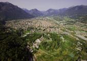
From Graniga on nice mule tracks we go down to Saint Lorenzo and thus to Bognanco Fonti. At the end of the village, in correspondence of a house of an intense green color, we take the Doo path towards Ca’ Monsignore, which can be reached having passed the trough of the Rio Rabianca river on a nice stone bridge. The path first follows along the mountainside and then goes down steeply to a torrent which can be crossed via a small stone bridge thus allowing us to reach in a brief amount of time the Dagliano Oratory. Following first in a slight uphill path and then flatly on the nice mule track we come to Monteossolano. Having left the church dedicated to Saint Gottardo, we follow on a paved road reaching Pregliasca. From here, first along a fire road running across the hillside surpassing a few streams and then along a steep mule track in the woods, we go down to Cisore and thus on a perfectly preserved mule track we reach Mogogna. We cross the road bridge on the Bogna Torrent and going down along the carriageable road we reach Castanedo. From here we take a wide, optimally preserved, mule track which goes up to Vagna (Maggianigo). Around Vagna many chapels and oratories disparaged across the woods tell about the local popular religiousness (for instance, the Baby Jesus Procession (Processione del Bambin) is held in June with the traditional small baskets “cavagnette”). We thus in a brief amount of time go back up to Croppo and proceeding first along a path in the woods, and then along an unpaved road, we reach the agglomerate of Motto and the Marisch Chapel. Finally, on a nice mule track with big steps we go down to the Sacred Mount Calvario Square, declared by Unesco as a UNESCO World Heritage Site. Following the Crucis Way we go down to Domodossola and in a brief amount of time we reach its historical centre and train station.
Recommended period
Accessible to people with disabilities
Support points
Possibility of accommodation and refreshment in San Lorenzo, Bognanco Fonti, Mocogna.
A Line bus connects San Lorenzo (Bognanco) with Domodossola (www.comazzibus.com)
Interest points
The Church of San Lorenzo (Bognanco). The Thermal Center of Bognanco Fonti. The Dagliano ravine with the spectacular stone bridge. The characteristic town of Monteossolano with the ancient wine press. The terraces of Cisore. The Sacred Mount Calvary, declared a UNESCO World Heritage Site. Around Vagna many chapels and oratories scattered in the woods tell of the local popular religiosity. The remains of the Castle of Mattarella. The historic centre of Domodossola
Dettagli
Profilo altimetrico
Dati tecnici
- Code
- STK
- Classification
- Provincial - Mid and Low Altitude
- Local Tourist Agency (LTA) reference
- ATL Distretto Turistico dei Laghi
- Country
- Italy
- Region
- Piemonte
- Province
- Verbania
- Devotional relevance
- No
- Historical relevance
- Yes
- Ultima data di aggiornamento
- 15/12/2023
Altre info
Accommodation facilities

Villaggio "yolki palki"
- Località
BOGNANCO (VB)

Da cecilia
- Località
BOGNANCO (VB)

Domodossola
- Località
DOMODOSSOLA (VB)

Europa
- Località
DOMODOSSOLA (VB)

Internazionale
- Località
DOMODOSSOLA (VB)

Biglia
- Località
DOMODOSSOLA (VB)

Corona
- Località
DOMODOSSOLA (VB)

Eurossola
- Località
DOMODOSSOLA (VB)
Tappe
Tappe attività
-
0VIA STOCKALPER - Val BognancoLunghezza66.50 kmTempo22 hours 10 minutesDifficoltàHiking
-
1VIA STOCKALPER Stage 1: Brig - Simplon PassLunghezza14.00 kmTempo5 hours 50 minutesDifficoltàHiking
-
2VIA STOCKALPER Stage 2: Passo del Sempione - GondoLunghezza19.00 kmTempo4 hours 40 minutesDifficoltàHiking
-
3VIA STOCKALPER Stage 3: Gondo - GranigaLunghezza19.00 kmTempo6 hours 40 minutesDifficoltàHiking
-
4VIA STOCKALPER Stage 4: Graniga - DomodossolaLunghezza14.50 kmTempo5 hoursDifficoltàHiking
