- Lenght
- 19.00 km
- Tempo
- 4 hours 40 minutes
- Tappa
- Ascent elevation gain
- 70 m
- Descent elevation loss
- 1270 m
- Difficulty
- Hiking
- Itinerary index
- No
Informazioni
Punto di partenza
Passo del Sempione
3907 Sempione
Switzerland
Punto di arrivo
Gondo
3901 Zwischbergen
Switzerland
Come arrivare
The Sempione Pass and Gondo can be reached from Italy and Switzerland by the Sempione National Road
Railway stations of reference Domodossola (IT) and Briga (CH). Timetable: www.trenitalia.com; www.bls.ch
By bus: Domodossola postbus - Brig. Timetable: www.autopostale.ch
Descrizione
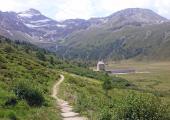
Following the usual track marks with brown directional arrows and the name “Stockalperweg” (track mark 90), from the Sempione Mountain Pass we start going downwards always keeping at the bottom of the valley and always more or less at an offset to the cantonal road. We pass the whereabouts of Hiwe, with its Baron Stockalper Hospice, and thus follow on to Nideralp, Chiusmatte, and Engiloch. On the nice mule track which unwinds on the side of the main road we cross the pastures of Maschihus and arrive at Egga and thus to Siplon Dorf. From here onwards the path goes down to Gabi and in correspondence of the Alte Kaserme (historical transportation museum along Sempione) we start an emotional journey with metal overpasses and high bridges which cross the Gondo Gulleys. We cross the military fort of Gondo and at last reach Gondo, at the Italian-Swiss boundary.
Recommended period
Accessible to people with disabilities
Support points
Accommodation in Engiloch, Simplon, Gaby
A Swiss Post Office bus connects the Simplon Pass with Gondo
Interest points
The Hospice of the Simplon (now known as the Old Hospice or Alter Spittel). Some stretches of the ancient mule track and the Napoleonic Road. The small Walser villages. The village of Simplon Dorf with its massive houses. The Simplon Ecomuseum. Gabi with ruins of an ancient warehouse of storage of goods. The suggestive Gorges of Gondo. The military fort of Gondo. The Museum Alte Kaserme.
Dettagli
Profilo altimetrico
Dati tecnici
- Code
- STK
- Classification
- Provincial - Mid and Low Altitude
- Local Tourist Agency (LTA) reference
- ATL Distretto Turistico dei Laghi
- Country
- Switzerland
- Region
- Canton du Valais
- Other
Different accommodation options at the Simplon Pass and at Gondo www.brig-simplon.ch
- Devotional relevance
- No
- Historical relevance
- Yes
- Ultima data di aggiornamento
- 15/12/2023
Tappe
Tappe attività
-
0VIA STOCKALPER - Val BognancoLunghezza66.50 kmTempo22 hours 10 minutesDifficoltàHiking
-
1VIA STOCKALPER Stage 1: Brig - Simplon PassLunghezza14.00 kmTempo5 hours 50 minutesDifficoltàHiking
-
2VIA STOCKALPER Stage 2: Passo del Sempione - GondoLunghezza19.00 kmTempo4 hours 40 minutesDifficoltàHiking
-
3VIA STOCKALPER Stage 3: Gondo - GranigaLunghezza19.00 kmTempo6 hours 40 minutesDifficoltàHiking
-
4VIA STOCKALPER Stage 4: Graniga - DomodossolaLunghezza14.50 kmTempo5 hoursDifficoltàHiking
