- Lenght
- 0.50 km
- Tempo
- 4 hours 30 minutes
- Tappa
- Dislivello salita
- 250 m
- Difficoltà
- Challenging
- Indice itinerario
- No
Informazioni
Punto di partenza
Foresto Bussoleno
Foresto Bussoleno TO
Italy
Punto di arrivo
Italy
Come arrivare
Descrizione
ACCESS
From Turin A32 motorway exit San Giorio take direction Chianocco turn left towards Bussoleno. From the town of Bussoleno Susa head along the SS 25 after two Km. Turn right. towards the 'village of Foresto, reached the square of the Church park.
ITINERARY
From the car park take the road on the right. immediately after the bridge over the Rio Rocciamelone, follow it until the end of the asphalt, continue along the flat dirt road leading into the 'Orrido, 10 min. from the parking lot.
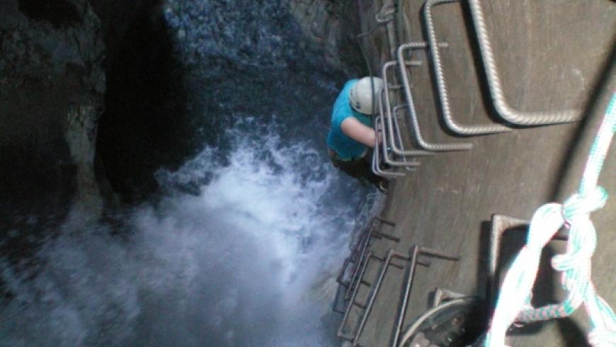
Go past the climbing gym and face the first ford on a tiny barrier, easily up the bottom of the stream until the canyon tightens, then face the second ford and go to the start of the Via Ferrata.
Take the first part, simple and a few meters above the water, until the beginning of the first cascade, easy steps to overcome, after which you will come across the first rope bridge, which diagonal pattern deposited us on the opposite bank, a short crossing horizontally on overhanging rocks, to reach the second rope bridge that brings us to the right bank of the canyon. From which begins the long traverse with ascending path, leads into the throat becomes narrower gradually and reach the characteristic amphitheater of the second cascade, overcome along a vertical scale to over 30 m. So with easier route but very suggestive reach the third ford, which gives access to the third waterfall, the first stretch easy but often wet leads to a small overhang above which an aesthetic sideways you reach the third Tibetan bridge. Beyond which you cross a tiny forest in the gorge, turning over an edge and you enter the beautiful Marmitta dei Giganti that gives rise to the fourth waterfall; after which the environment changes, becoming wider and brighter. Climb now along a dihedral angle in order to step over a small ridge and then take on one last vertical wall, beyond which you enter the forest for the moment still very steep, follows the cable along a track of the path until the end of the difficulties . Still a steep trail equipped with a few twists and turns leads us at the top.
DESCENT
At the end you will meet the descent trail signed Foresto.
Note: Environment itinerary, with sheer drops. The path must not be approached in case of floods or when the stream has a high flow of water especially during spring when the snow has melted, during periods in which there are significant rainfall or thunderstorms. In the winter period although there are shortages of water you can find the presence of ice on the course.
Accessible to people with disabilities
Dettagli
Dati tecnici
- Esposizione
- Sud
- ATL di riferimento
- ATL di Torino
- Nazione
- Italy
- Regione
- Piemonte
- Provincia
- Torino
- Dislivello di avvicinamento
- 30 m
- Altro
Città Metropolitana Torino
Alpi Cozie
Bassa Valle Susa
- Interesse devozionale
- No
- Interesse storico
- No
- Ultima data di aggiornamento
- 15/12/2023