- Lenght
- 16.00 km
- Tappa
- 3 / 3
- Max altitude
- 2313 m
- Ascent elevation gain
- 1060 m
- Descent elevation loss
- 35 m
- Difficulty
- Challenging
- Itinerary index
- No
Informazioni
Punto di partenza
Formazza Frazione Ponte
28863 Formazza VB
Italy
Punto di arrivo
Passo San Giacomo
28863 Formazza
Italy
Come arrivare
SS33 del Sempione, Exit Crodo Valle Antigorio - Valle Formazza, and continuing on SS 659 you reach Ponte Formazza.
All the villages of the Antigorio Formazza Valley are served by the Domodossola-Cascata del Toce bus line.
Autoservizi Comazzi
Tel. 0324 240333
www.comazzibus.com
Descrizione
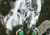
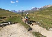
From Ponte you begin to climb up a wide track which, above Brendo, becomes a path that takes you to Grovella. Now the route becomes steeper and to get to Canza you have to climb a ridge (the Cree) where cycling is impossible. On arriving at Canza do not cross the river but continue on a track which runs alongside the river. A little further on it becomes a steep path where cycling is impossible and which crosses another ridge before coming to Sottofrua. From here you can continue straight on along the wide path which leads to the bridge right at the foot of the Cascata del Toce (Toce waterfall). Alternatively you can cross the little wooden bridge immediately and take the state highway with the artificial tunnel which leads to the top of the waterfall. Climbing the mule track alongside the waterfall is not recommended as it is very steep, with large steps where cycling is impossible and which is busy with walkers. On arrival at the top of the waterfall continue to Riale following the tarmac road or the old mule track (signposted G00). When you come to the Centro del Fondo (Cross Country Ski Centre) of Riale cross the little bridge over the River Toce and follow the whole road of the San Giacomo Pass which was built in the nineteen twenties for the construction work on the Toggia and Castel dams. It is a real masterpiece, with low gradient and perfectly aligned hairpin bends. At the end of the uphill stretch you come to the Rifugio Maria Luisa (Maria Luisa Refuge) and then the Diga di Lago Toggia (Lake Toggia Dam). From here the road climbs gently skirting above the entire lake. Ignoring the turn off for Alpe Regina go straight on to the San Giacomo Pass where you can see the Bedretto Valley below.
From the pass you can co down into the Bedretto Valley to Airolo along the route promoted by Ticino Turismo know as the Strada degli Alpi (Road of the Alps), which half way up the slope passes the Alps of Formazzora, Valleggia, Folera, Stabiello, Cristallina and Pescium.
Recommended period
Accessible to people with disabilities
Support points
BIKE RENTAL: Cross Country Ski Centre Riale c/o Aalts Dorf Hotel Riale - 28863 Formazza VB www.centrofondoriale.com www.mountainsportformazza.com
Interest points
Toce Waterfall, Walser culture at Formazza, Casa Forte di Ponte, Lakes of the Val Formazza
Dettagli
Profilo altimetrico
Dati tecnici
- Code
- TOC
- Classification
- Provincial
- Local Tourist Agency (LTA) reference
- ATL Distretto Turistico dei Laghi
- Cell phone coverage
Ok
- Country
- Italy
- Region
- Piemonte
- Province
- Verbania
- Devotional relevance
- No
- Historical relevance
- No
- Ultima data di aggiornamento
- 31/01/2025
Tappe
Tappe attività
-
-
1MTB del Toce - Stage 1: Montecrestese - PremiaLunghezza17.70 kmTempoDifficoltàEasy
-
2MTB del Toce - Stage 2: Premia - FormazzaLunghezza18.70 kmTempoDifficoltàEasy
-
3MTB del Toce - Stage 3: Formazza - Passo San GiacomoLunghezza16.00 kmTempoDifficoltàChallenging

